Following the devastating fire in 2003 a successful program of active stabilisation and regeneration of the moor was put in place. These pictures were taken a couple of years after the fire
If you are interested in the Prehistoric Rock Art of the North Yorkshire Moors, I would recommend getting hold of a copy of Prehistoric Rock Art in the North York Moors by Graeme Chappell and Paul Brown
Walking from Farndale up towards Rudland Rigg, we followed the track up the side of Monket Bank. The track climbs up through the old jet workings and quarries along the moor edge.
In the 14th century this route was known as Monckgate and linked Bransdale with Farndale. The track was used as a Church or Corpse Road with coffins being carried over the rigg to Cockan Kirk in Bransdale.
The road across the rigg is now known as Westside Road, in the past, it was known as Waingate, running from Kirkbymoorside Market Place in the south to Battersby Bank in the north.
We cut out across the moor towards Ousegill Head and the Three Howes. Flint tools had been found by the gamekeepers for a number of years so in September 1973 Raymond Hayes and others excavated the area. His small excavation yielded over 800 flints from an area of 3.50 x 3.0m. The site was interpreted as ‘A temporary camping site in a forest clearing, probably being occupied by hunters following red deer or other game.’
Whilst at the Three Howes we saw a Red Kite being harassed by an anxious Curlew. Once the Kite had rid itself of its tormentor it flew directly over us, a joyful moment, this was my first sighting of a Kite on the moors.
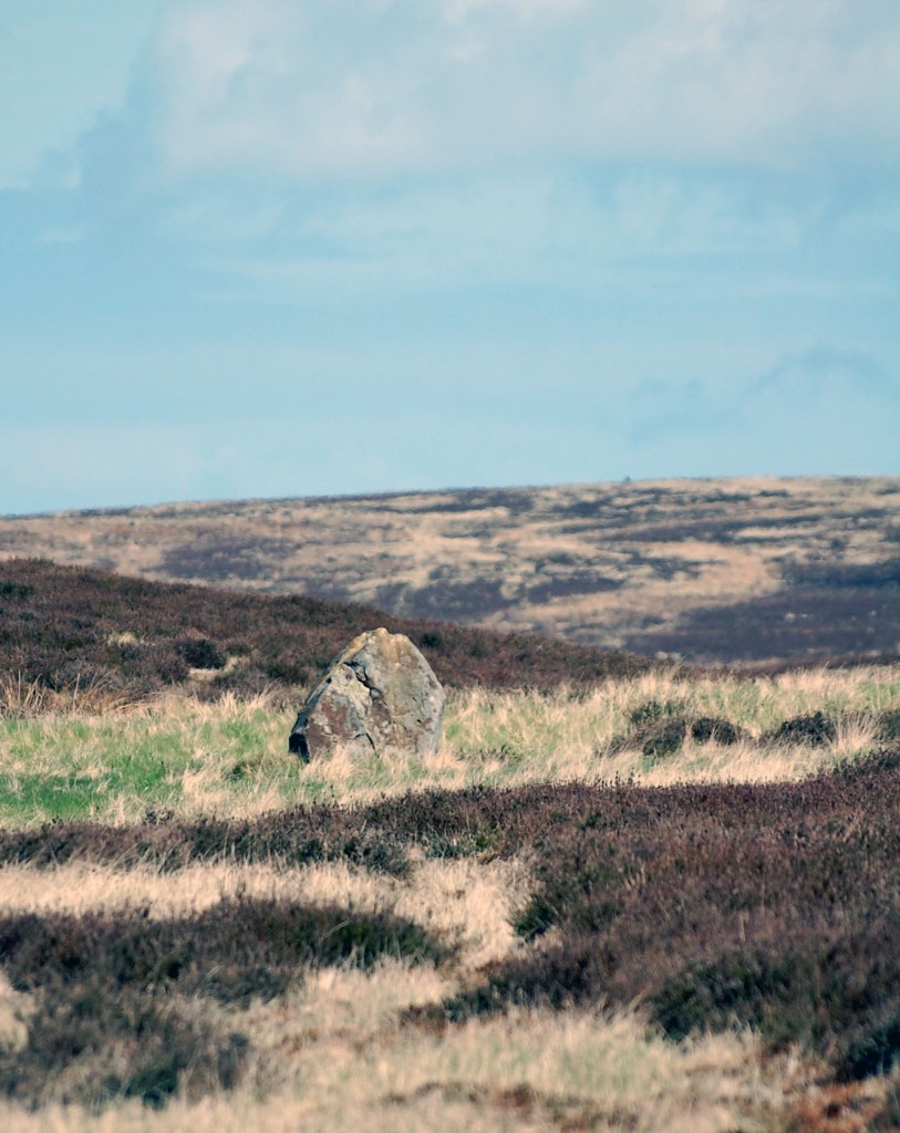
We walked back across the old peat workings and rejoined the track, moving on to the waymarker at Cockam Cross and then onto our final goal, the Cammon Stone.
The Cammon Stone is a prehistoric standing stone that sits just beside the main track. The stone is about a metre and a half tall and leans towards the west. I have been visiting this stone on and off for at least two decades, my perception is that the lean of the stone has increased over the years but I may be wrong, I hope I am. The southern views from the stone look down along Bransdale, the axis of the stone is also aligned in this direction, which is probably no coincidence.
There are a number of faded letters carved onto the western face of the stone, in the past, antiquarians had speculated as to whether these letters were Phoenician in origin. They are actually Hebrew and spell out the word halleluiah. They are thought to be the work of the Reverend W Strickland, Vicar of Ingleby. Strickland is thought to be responsible for carving a number of inscriptions in this area.
There is a second stone, a large flat slab. No one knows whether this slab ever stood upright. There is no obvious weathering patterns to indicate that it might have been upstanding but I guess that question could only ever be answered by an archaeological investigation.
We picked our way along a track that ran from the moortop into Farndale and joined the daleside road at Spout House. If you are a fan of stone walls and troughs, you will love this road, it has massive walls with stone-lined gutters and numerous multiple carved stone troughs. The stonemasons and wallers were once kept busy in this area.
Also on this road is the Duffin Stone, a massive boulder that has tumbled down from the escarpment side and is embedded into the verge of the narrow lane. The stone bears the scars of contact with many vehicles.
Etymology
Waingate – OE Waen Way – Waggon Road
Monket – The ‘Mun(e)k(e)’ spellings suggest ‘monks’, but in the absence of monastic associations one might suspect an earlier ‘Mened-cet’ (Welsh Mynydd-coed) – ‘forest hill’. Here one might compare ‘Monket House’ in north-east Yorkshire.
Cammon Stone – Cam Maen – Bank Stone.
Rudland – OE hrycg ON hyrggr ‘ridge’.
Sources
Old Roads & Pannierways in North East Yorkshire. R. H. Hayes.1988. The North York Moors National Park.
Yorkshire Archaeological Journal. Vol.67. 1995. The Yorkshire Archaeological Society.
The Consise Oxford Dictionary of English Place-Names. Eilert Ekwall. 1974. Oxford.
A few years ago I bought an album of old french postcards themed around prehistoric monuments and natural rock features.
This sparked a short obsession with prehistoric postcards. I bought most of them from ebay and boot sales, setting myself the challenge of paying no more than a pound or two for each card. The obsession burned itself out after a year or two so and I decided to put the collection online for anyone to use. I uploaded about a third of the cards and then kind of lost interest. I’ll return to it one day and finish the job.
If this sort of thing interests you, the collection can be found here
My friend Tony Galuidi asked me if I’d be interested in a joint exhibition, I agreed and here it is. If you like big old prehistoric stones and you happen to find yourself in Cumbria, pop in and have a look.
My friend Graeme Chappell and I decided to have a wander around Thompson’s Rigg. We followed the Old Wife’s Way from Horcum, dropping down along Newgate Brow into the valley below.
We crossed the fields to take a look at the standing stones at the foot of Blakey Topping. These stones have been interpreted as a possible ruined stone circle.
After spending some time at the stones we walked onto Thompson’s Rigg. The Rigg is only a mile long, its flanks slope down into the valleys of the Grain Beck to the East and Crosscliff Beck to the west. The moor is surrounded on three sides by higher ground and gently slopes to the south where it narrows to form a valley which eventually leads to Langdale End and Howden Hill, a hill very similar in appearance to Blakey Topping.
About a third of the way along the Rigg the trackways bends, at this point, running diagonally to the trackway, is a cross ridge boundary. The boundary is a banked structure that bisects the full width of the moor and is topped, in parts, with large stones. The official scheduling for the area states that, Although this boundary forms part of the post-medieval field boundary system in the area, it is considered to incorporate elements of an earlier construction which had origins in the prehistoric period, contemporary with the cairnfield. source
In his book Early Man in North East Yorkshire Frank Elgee wrote, A wall of upright stones crosses the Rigg between the farm and the barrows, he also includes the boundary on his map of the area
It is curious that despite the earthwork being mentioned in the official scheduling of the area and despite it defining the the northern limit of the cairnfield and barrows and its close resemblance to other moorland cross ridge boundaries, this significant structure does not appear in either Don Spratt’s 1993 or Blaise Vyner’s 1995 inventories of the cross ridge boundaries of the North York Moors.
South of the large boundary earthwork we started to encounter many cairns, most are in deep heather and difficult to define, at least one of this group appears to be a large ruined barrow.
We continued south, traipsing through the deep heather to a grassy area containing a beautiful Platform Cairn. Platform Cairns are rare on the North York Moors, they are defined as, A roughly circular monument featuring a low, more or less level platform of stones surrounded or retained by a low stone kerb. Some may feature a small central open area, thus resembling a ring cairn. Source.
There is a large stone and hollow in the middle of the cairn implying a possible ruined cist, it is evident that this cairn had been excavated in the past. Graeme reminded me that we were only seven miles from Pickering, once home to James Ruddock.
James Ruddock was a nineteenth century commercial barrow digger. Between 1849 and his death in 1859 he opened many of our moorland mounds in search of finds to sell to the gentleman collectors of his time. His main client was the antiquary Thomas Bateman, he also opened barrows for Samuel Anderson of Whitby.
Unfortunately Ruddock did not always keep precise notes regarding the locations of his diggings, many of his finds have ended up in our museums with vague labels such as, from a mound 6 miles north of Pickering.
Moving further south we encountered this lovely, fairly well-defined ring cairn.
On the south eastern flanks of the Rigg is a group of hollow ways, these are not considered to be prehistoric.
At the southern end of the Rigg is this orthostatic wall which contains many large stones, some of which appear to be buried into the ground. If the wall contained unburied stones it would be classed as a boulder wall. The walling is definitely not prehistoric but may contain stones from an earlier feature.
Not far from the walling is this three foot high standing stone, located within an area of low banks and cairns at the southern end of the Rigg.
Blakey Topping and Thompson’s Rigg are well worth a visit, There is a wealth of prehistoric remains to be seen within a relatively small area. The area is owned by the National Trust and is not managed for grouse so has a mixture of habitats, we saw plenty of birds including Skylarks, Snipes and what I think were a large flock of Fieldfares.
If you visit this lovely place, what you’ll undoubtably notice is that wherever you are on the moor, Blakey Topping is the dominant landscape feature. Graeme and I agreed that this beautiful hill probably had a deep significance to the original inhabitants of this area. A sacred hill? perhaps even a sacred landscape?
Resources
Early Man in North East Yorkshire. Frank Elgee. 1930
Orthostatic Field Walls on the North York Moors. D A Spratt. YAJ Vol. 60. 1988
Linear Earthworks of the Tabular Hills, Northeast Yorkshire. D A Spratt. 1989
Prehistoric and Roman Archaeology of North-East Yorkshire edited by D A Spratt. 1993
CBA Research Report 101: Moorland Monuments’ in The Brides Of Place: Cross-Ridge Boundaries Reviewed, B Vyner. 1995
Howe Hill is a prominent mound in the centre of the village. It was previously thought to be a Norman earthwork or Motte but is actually a prehistoric burial mound dating from the Late Neolithic period to the Late Bronze Age. The site is still marked on the modern maps as a Motte.
The barrow has a beautiful tree growing on it and sits upon a natural knoll that has been bisected by the main road into the village. The primary views from the barrow are to the west across the Vale of Mowbray to the distant Pennines.
There is a Norman connection with the village, the local church was rebuilt in the mid-nineteenth century contains a number of Romanesque carved stones including this lovely capital depicting foliate heads.
I recently saw this wonderful illustration of Yorkshire Megaliths. I contacted the author, Adam Morgan Ibbotson, and he kindly sent me a copy.
I was rather chuffed, Adam wrote one of my favourite books of 2021, Cumbria’s Prehistoric Monuments. It’s a lovely book, comprehensive, very readable with beautiful photographs, maps and illustrations. If prehistory and big old stones are your thing, you’ll love this. You can buy it here
Near Moor is a moor on the western margins of the Cleveland Hills. The moor is at its highest in the north-east where it meets the wooded escarpment edge of the Cleveland hills, it then slopes gently southwards towards Crabdale. Near moor is bounded by Far Moor To the East, Pamperdale Moor to the South and the valley of Scarth Nick and Scarth Wood Moor to the west.
The moor is managed for grouse shooting. The vegetation of the moor is predominantly heather with patches of moorland grasses and sedges.
The rocks here are mainly Jurassic Sandstones, formed 170 million years ago in shallow estuaries and deltas. To the north, below the escarpment edge, there are many old jet workings. Blocks of ‘White Flint’ can be found on the moor-top.
Both Near Moor and the adjacent Scarth Wood Moor were used by our ancient ancestors, there are the remains of ancient walls, enclosures, trackways and cairns dotted across both moors.
There are a number of cup-marked rocks on the moor, all are very weathered and barely recognisable.
There are the remains of quarries on the margins of the moor, local stone masons also used the prehistoric walls as a source of stone.
I needed to unravel a few knots and put some ground under my boots. I was undecided as to where to go…time for the coin. A flip of the coin as to whether it would be moorland or coastal, a second flip to decide on a old favourite or a new site. The outcome, coastal/new.
A while ago I was reading about the Boulby Alum Quarries, I’d never visited the place, I did once try to get there via the the Loftus quarries but failed. I had read that Boulby was one of the best examples of its kind in the country, so that was that, Boulby was the place.
I walked along the Cleveland way to Rockhole, looking for a path into the quarry. All I could find was the trace of a track heading towards Rockhole Hill. I followed the track which got fainter and fainter and took me deep into the quarry. The vegetation got higher and thicker and the track eventually petered-out completely at a large pile of droppings. I’d been following a rabbit track which had led me into a deep thicket of gorse and brambles. I looked for a way forward but couldn’t seen anything that resembled a path.
I had a choice, try and push forward through the quarry or retrace my steps back up to the main footpath and start again. I decided to push on and look for another path. I thought that if I could skirt around Rockhole hill towards the cliff edge I would come across a path, a simple enough plan. The problem was that the foot of the hill and the quarry floor is covered in chest-high rosebay willowherb, bracken, gorse, brambles and boulders, there are also a number of small, steep-sided beck channels concealed beneath the vegetation. The flanks of the hill are steep but less treacherous, they are covered with deep heather and large, impenetrable patches of gorse and brambles. It took me about half and hour of constant scrambling and slipping to cover the short distance to the cliff edge.
Much to my relief, my efforts eventually led to an overgrown track that looked as though it was heading towards the main quarry and alum works. After that it was fairly plain sailing, there were still patches of gorse and brambles to get around but the ground was fairly level and the surrounding vegetation was fairly low.
Moving along the track I began to noticed low walls, the remains of a building, a stone-covered culvert and two beautiful circular stone-lined tanks. The production of Alum started here in the mid 1600s, the Rockhole quarries and structures are the oldest part of the site.
I continued to walk north into the later sections of the works and suddenly found myself standing in the quarry, an amphitheatre of alum, ruins of massive stone walls and heaps of alum shale, facing the sea and backed by the massive sandstone cliffs, a wonderful sight.
The cliffs are never static, large blocks litter the site, some bearing fossils.
Walking around the ruins, the mind starts to wander. It is easy to forget that this was a place of industry and imagine that these are the remnants of a cliff-edge citadel whose myths are still waiting to be discovered.
These cliffs are the highest point on the east coast of our island. The land above the quarry has been occupied for thousands of years, its soils contains the evidence of the district’s earliest house. Archaeologist Steve Sherlock has also found evidence of prehistoric salt production and jet working on the land behind the clifftop, evidence of early industry, albeit on a small scale. Our prehistoric ancestors performed rituals and buried their dead on these clifftops. It is also the location of the famous Saxon Princess burial.
I left the quarries and followed the path that runs between Rockhole Hill and the cliff edge. The track is becoming overgrown, an indication that this site doesn’t see many visitors. A couple of short sections of the path have eroded away, this is not a place for anyone who is nervous of walking along a cliff edge. The track leads back to the Cleveland Way via a couple of lovely tiny woods, shoehorned into the short valleys running down to the cliff tops.
If you are going to visit the quarries I would advise that you avoid following the track down into the Rockhole Quarry, my legs are covered in small cuts, pin-cushioned by brambles and gorse and it took a fair bit of effort to escape the quarry. The cliffs along this part of the coast can be unstable, the track around Rockhole Hill is difficult to find but definitely the one to take, however it is not without danger and should be approached with great caution.