In 2004 Graeme Chappell and I were fortunate enough to visit the ongoing excavation on Fylingdales Moor.
It was in what was thought to be an early Bronze Age ring cairn that a late Neolithic intricately carved stone was found. This has become the best known discovery on the moor made in the aftermath of the fire. A further stone bore grooves and cup-marks similar to those found on the nearby earthfast rocks. The stones have been placed in a ring as the end point of what may have been a long period of ritual significance.
I recently found a bag of photographs that I thought were lost. Amongst the photographs were a few that I took in 2003 after a devastating fire swept across Fylingdales Moor. The fire burned off the peat deposits along with dense heather and bracken cover and in the process gave us a brief look at the prehistoric landscape that potentially exists beneath many of our moorlands.
The fire revealed a wealth of archaeology on the moor ranging from prehistory to the Second World War. If you are interested in finding out more I’d recommend seeking out Local Archaeologist Blaise Vyner’s excellent booklet, Fylingdales Wildfire and Archaeology. 2007. Published by North Yorkshire National Park.
My friend Graeme Chappell and I decided to have a wander around Thompson’s Rigg. We followed the Old Wife’s Way from Horcum, dropping down along Newgate Brow into the valley below.
We crossed the fields to take a look at the standing stones at the foot of Blakey Topping. These stones have been interpreted as a possible ruined stone circle.
After spending some time at the stones we walked onto Thompson’s Rigg. The Rigg is only a mile long, its flanks slope down into the valleys of the Grain Beck to the East and Crosscliff Beck to the west. The moor is surrounded on three sides by higher ground and gently slopes to the south where it narrows to form a valley which eventually leads to Langdale End and Howden Hill, a hill very similar in appearance to Blakey Topping.
About a third of the way along the Rigg the trackways bends, at this point, running diagonally to the trackway, is a cross ridge boundary. The boundary is a banked structure that bisects the full width of the moor and is topped, in parts, with large stones. The official scheduling for the area states that, Although this boundary forms part of the post-medieval field boundary system in the area, it is considered to incorporate elements of an earlier construction which had origins in the prehistoric period, contemporary with the cairnfield. source
In his book Early Man in North East Yorkshire Frank Elgee wrote, A wall of upright stones crosses the Rigg between the farm and the barrows, he also includes the boundary on his map of the area
It is curious that despite the earthwork being mentioned in the official scheduling of the area and despite it defining the the northern limit of the cairnfield and barrows and its close resemblance to other moorland cross ridge boundaries, this significant structure does not appear in either Don Spratt’s 1993 or Blaise Vyner’s 1995 inventories of the cross ridge boundaries of the North York Moors.
South of the large boundary earthwork we started to encounter many cairns, most are in deep heather and difficult to define, at least one of this group appears to be a large ruined barrow.
We continued south, traipsing through the deep heather to a grassy area containing a beautiful Platform Cairn. Platform Cairns are rare on the North York Moors, they are defined as, A roughly circular monument featuring a low, more or less level platform of stones surrounded or retained by a low stone kerb. Some may feature a small central open area, thus resembling a ring cairn. Source.
There is a large stone and hollow in the middle of the cairn implying a possible ruined cist, it is evident that this cairn had been excavated in the past. Graeme reminded me that we were only seven miles from Pickering, once home to James Ruddock.
James Ruddock was a nineteenth century commercial barrow digger. Between 1849 and his death in 1859 he opened many of our moorland mounds in search of finds to sell to the gentleman collectors of his time. His main client was the antiquary Thomas Bateman, he also opened barrows for Samuel Anderson of Whitby.
Unfortunately Ruddock did not always keep precise notes regarding the locations of his diggings, many of his finds have ended up in our museums with vague labels such as, from a mound 6 miles north of Pickering.
Moving further south we encountered this lovely, fairly well-defined ring cairn.
On the south eastern flanks of the Rigg is a group of hollow ways, these are not considered to be prehistoric.
At the southern end of the Rigg is this orthostatic wall which contains many large stones, some of which appear to be buried into the ground. If the wall contained unburied stones it would be classed as a boulder wall. The walling is definitely not prehistoric but may contain stones from an earlier feature.
Not far from the walling is this three foot high standing stone, located within an area of low banks and cairns at the southern end of the Rigg.
Blakey Topping and Thompson’s Rigg are well worth a visit, There is a wealth of prehistoric remains to be seen within a relatively small area. The area is owned by the National Trust and is not managed for grouse so has a mixture of habitats, we saw plenty of birds including Skylarks, Snipes and what I think were a large flock of Fieldfares.
If you visit this lovely place, what you’ll undoubtably notice is that wherever you are on the moor, Blakey Topping is the dominant landscape feature. Graeme and I agreed that this beautiful hill probably had a deep significance to the original inhabitants of this area. A sacred hill? perhaps even a sacred landscape?
Resources
Early Man in North East Yorkshire. Frank Elgee. 1930
Orthostatic Field Walls on the North York Moors. D A Spratt. YAJ Vol. 60. 1988
Linear Earthworks of the Tabular Hills, Northeast Yorkshire. D A Spratt. 1989
Prehistoric and Roman Archaeology of North-East Yorkshire edited by D A Spratt. 1993
CBA Research Report 101: Moorland Monuments’ in The Brides Of Place: Cross-Ridge Boundaries Reviewed, B Vyner. 1995
In common with most people I feel as though many aspects of my life have been on hold for the past 12 months. My list of places to visit gets longer and longer. Now that lockdown is easing I seem to have a mental log-jam of what to do and what to see.
I have been planning on visiting the Cross Dyke of Horn Ridge for quite some time as it is one of the few local dykes that I haven’t visited. Once again, it was a chance online conversation with a friend that spurred me into action.
The sun was shining, the forecast was giving out wintery showers, this was perfect for me, half decent weather and less chance of meeting anyone on the moor-top.
I drove down to Farndale and walked up the keepers track that runs up the side of Monket House Crags. The track is not too steep and takes you through an area covered in spoil heaps from the 19th century jet workings. When I started walking the sun was shining, within a few minutes a wintery squall blew in from the north leaving a dusting of snow on the hillside. The squall was intense but short-lived, this became the pattern for the rest of the day.
I followed the track south along the gentle rise of Horn Ridge. From the high point the land begins to gently slope down to the south, the eye is drawn along the valley of the River Dove to the dale end with the moorland above Hutton Le Hole and the Vale of Pickering in the far distance.
As you walk down towards the very obvious earthwork you become very aware that you are on a narrowing promontory of moorland , the fertile dale on either side, hemmed in by the dark domineering presence of Rudland Rigg to the West and Blakey Ridge to the East. As you near the Dyke you can see through the central gap to a fairly level area with the barrow beyond, the effect is quite striking.
The Dyke itself runs the full width of the upland, terminating where the land drops off at either end. Its total length is approximately 300m.
Approaching it from the north it appears to be quite an impressive earthwork fronted by a deep ditch that has been dug along its whole length. When viewed from the south it appears less imposing.
A section of the Dyke was excavated by Raymond H. Hayes. He was unable to find any evidence that might give a date to the earthwork. He observed that with the ditch ‘its builders did not cut the rock as in Iron Age or Roman ditches.’
There are a couple of stone settings within the dyke on the south side but these look relatively recent, a modern shelter or grouse butt and a trap built by keepers to catch small mammals. These moors are not a friendly place for any creature that vaguely threatens the grouse population. Last year 5 dead Buzzards were discovered hidden beneath a rock just 3km north of the Dyke.
Walking south towards the barrow, a squall blows through and the views are lost.
The barrow is a sad sight. It’s quite large, approx 10-15m diameter. It’s hard to fully gauge the dimensions due to it’s in a terrible state of repair of the structure. The scheduling entry for the monument mentions ‘a central excavation hollow around 4m by 2m, with a second 1m diameter pit in its west side.’ The keepers have also recently built a trap into one of the holes in the mound.
I took wander over to the western edge of the ridge. There are reports of cairns and hut circles in this area. I was just starting to spot them when it started to snow quite heavily. My mind turned to driving home and having to tackle the steep bank from the dale bottom up to Blakey Ridge. Under normal circumstances I wouldn’t mind being trapped in Farndale but with the current conditions i.e. the Feversham Arms being closed, I decided that the western edge of Horn Ridge was one for another day and turned for home.
This morning I headed over to Westerdale Moor. I’ve been visiting this moor for many years and have always had the place to myself. As I walked up to the moor from Hob Hole I noticed a group of estate workers over on Little Hograh Moor, I made a small bet with myself that I’d be getting a visit from a gamekeeper within half an hour of setting foot on the moor.
The heather is in full bloom and the moors look stunning, after a few short minutes my boots were covered in a fine dusting of heather pollen. Later I encountered thousands of tiny bees congregating on a sandy bank at the side of the path, I presume these were Miner bees making the most of the pollen harvest.
My first landmark on the moor was the standing stone which can be seen from the footpath on the west end of the moor, this stone is below the crest of the ridge and is about 1.2m tall
Due north of the stone and about 100m over the ridge of the moor is an alignment of standing stones and boulders that runs for about 70m towards the Baysdale Beck, also known as the Hob Hole Beck. This alignment has been interpreted as a Bronze Age boundary and features in Blaise Vyner’s inventory of Cross Ridge Boundaries.
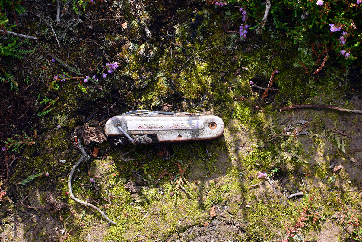
Returning to the path I noticed an object embedded in the dry mud at the side of the track. It was a Swiss Army knife, it had obviously been there for a while and had a name dymo-taped onto it, Roger Pybus. I pocketed the knife and a minute or two later noticed a large 4×4 pickup heading across the moor towards me, less than half and hour, I had won my bet.
I walked up to the pickup and had a chat with the keeper. He was friendly enough and told me that he was checking to ensure that I wasn’t going to have a barbecue or fly a drone over the moor. He told me about the sculpture that his boss had erected on the far horizon. I told him that I was more interested in standing stones and asked him if Roger Pybus was one of the blokes he worked with, he said he was so I gave him the knife to return to its’ owner.
On the skyline, Seated Man, a sculpture by Sean Henry commissioned by the estate owner David Ross and erected on Castleton Rigg. To the right of the sculpture are a group of visitors.
The keeper, satisfied that I wasn’t a hungry drone pilot, went on his way and I continued eastward across the moor. This side of the moor is dotted with low cairns and banks.
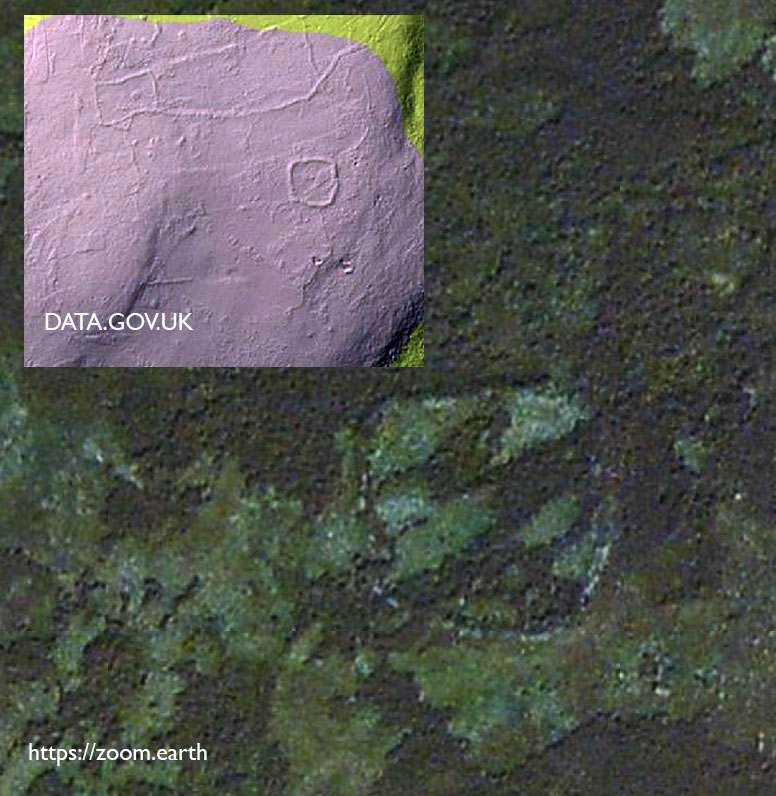
My next destination was the large embanked enclosure on eastern end of the moor. The enclosure is located on fairly level ground just before it dips down into the valley to where the River Esk meets the Baysdale Beck.
The Enclosure is about 40m square with fairly well defined walls. The walls are made of stones with the occasional large upright stone on the inner face. The walls stand at about 1.5m high and 2-3m wide. There is a 3m entrance on the east side. The general consensus is that the structure is Iron Age in date, but this is not certain.
I spent a little time walking around the enclosure and admiring the views along the Esk Valley to Castleton and then headed back to the road and Hob Hole via the Esk Valley Walk footpath.
Regarding the relationship between Hob Hole and the prehistoric remains, Stanhope White makes this observation
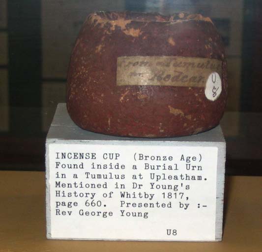
..the belief in a race of little men who lived under the earth may stem from the first interaction of the Celts with the indigenous Bronze Age people. When from time to time, a howe was opened for some purpose, possibly to win stone, if the so-called incense cups were found, they were regarded as proof of the presence of little men.
The North York Moors. An Introduction. Stanhope White. 1979
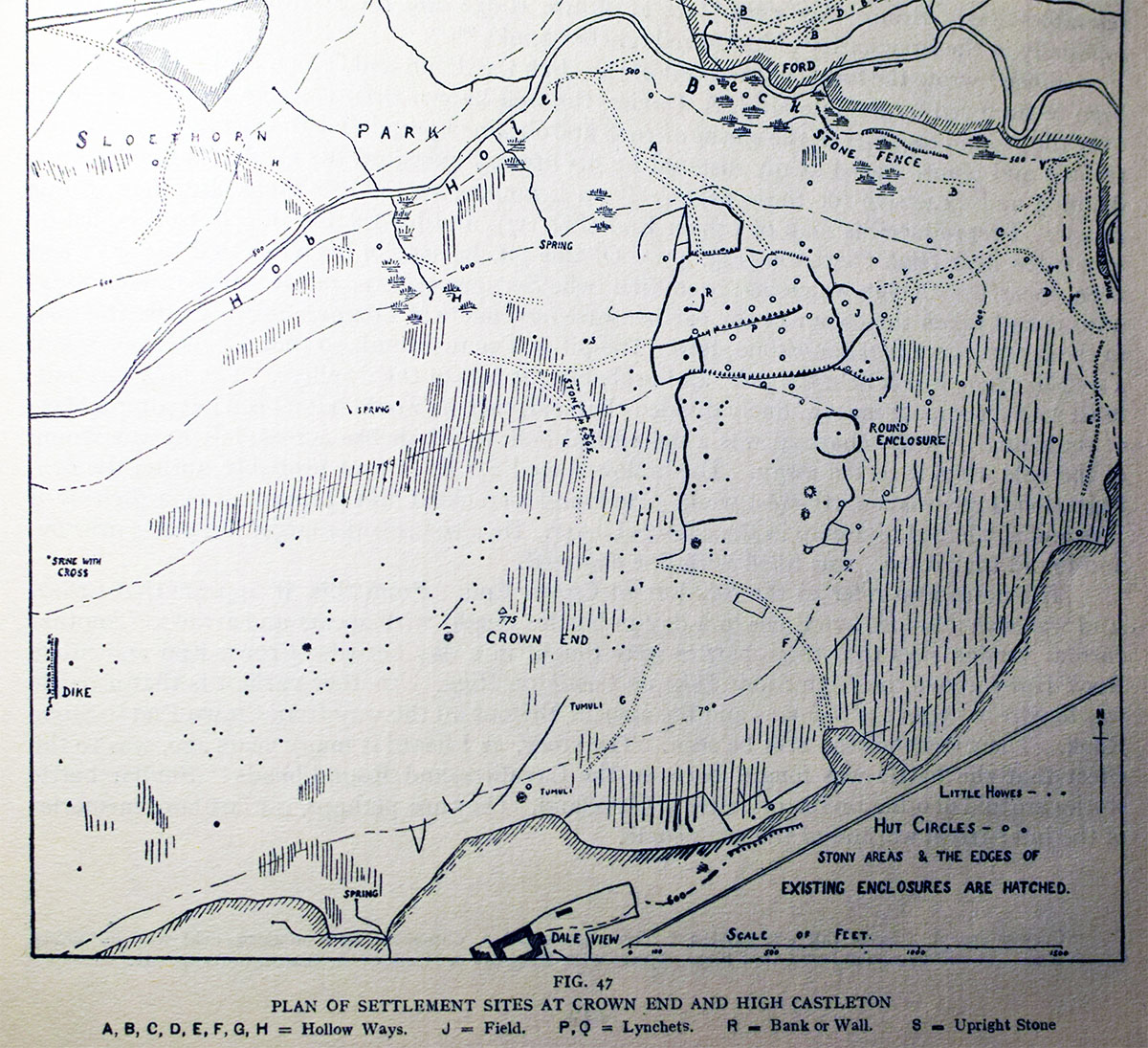
Frank Elgee’s map of Crown End.
A lidar image and aerial view of the Crown End enclosure
The rain has stopped, it’s time to get back onto the moors.
Gerrick Moor has a number of significant prehistoric monuments, a couple of good-sized barrows, a couple of hut circles, a late prehistoric enclosure and a cross dyke. All of this sounds very impressive but most of the features are quite subtle and take a little seeking out. There has also been a lot of later disturbance on the moor, it is riddled with old trackways, drainage ditches and grouse butts. The moor was also used as a tank training site during World War II.
The most prominent feature on the moor is Herd Howe, a large Bronze Age burial mound. The mound is situated on a ridge, best seen from the A174 heading east. The barrow is intervisible with a number of prominent prehistoric sites, The Black Howes to the west, Warsett Hill and Street Houses to the North, Skelder Hill (thanks Chris) and Danby Beacon to the East and views into the central moors to the south.
The mound was partially excavated by Atkinson in 1863. At the core was a pit which had then been covered with a stone cairn, the cairn was finally covered with a stone and earth mound.
In the pit Atkinson found the remains of eleven cremation deposits and fragments of seventeen vessels, one of which was accompanied by a stone battle axe. Other finds included pottery vessels, flint tools, two bone pins and a bone needle.
On a gently sloping area just below the mound is a banked enclosure. This enclosure has been interpreted as a late prehistoric enclosed settlement similar to the settlement at Box Hall.
Raymond Hayes recorded thirty six examples of these small rectilinear enclosures across the North York Moors. Once you located it’s not difficult to trace the boundary bank, it is mainly covered in Bilberry and stands out quite well against the background of heather. The bilberries are just coming out at the moment and are sweet and juicy, a welcome snack.
I headed off across the moor to check out the Cross Dyke that runs NW-SE for about three hundred meters. The dyke comprises a It a pair of banks with a central ditch running from the Tank road to the where the land starts falling off into Gerrick Haw.
Cross dykes are thought to a prehistoric territorial boundary. There are a number of similar dykes across the North York Moors, Blaise Vyner records at least fifteen, many of which are associated with prominent burial mounds. It is not unreasonable to speculate that these monuments had a ritual function.
The heather has just come into bloom on the south facing bank.
Looking down to the northern end of the dyke into Gerrick Haw towards Dimmingdale with Moorsholm Moor and the Black Howes in the distance.
Sources
Bronze Age Burial Mounds in Cleveland. G M Crawford 1980
North east Yorkshire Studies: Archaeological Papers. Raymond H Hayes 1988
Moorland Monuments CBA Research Report 101. Blaise Vyner 1995
Easington Moor (Danby Low Moor) can be a pretty damp place at the best of times, after recent rains the moor is well sodden. Crossing the moor is difficult, large tracts of sedge, cottongrass and sphagnum are best avoided. Away from the keepers tracks, walking a straight line between any two points on the moor without stepping into a bog is almost impossible
This area of the moor is rich in prehistoric monuments, I wanted to see if I could find a triangular stone setting described by Frank Elgee in his 1930 book, Early Man in NE Yorkshire.
Elgee’s description.. It lies immediately east of the large barrow..The stones form a right-angled triangle, one side of which is about 30 yards long, the other two about 24 yards. The stones are 5-7 feet long with broad bases.
The only stone I was able to locate. The large barrow is just beyond it, it is possible to make out the paltform beneath the barrow.
The burning of the heather and subsequent regrowth reveals the low bank and ditch that encloses Bella Dale Slack.
The Three Howes are on the rigg in the middle distance. The tufts of sedge in front of them indictate the location of the pits.
I was only able to locate one of Elgee’s stones, the photo above shows the stone with the barrow in the background. The barrow is unusual as it has been constructed on a low platform.
One of the pits with another in the distance filled with sedges, beyond that the barrow and Bella Dale Slack
Sedge filled paired pits
Beautiful golden sphagnum and ghostly white moss on a burned section of moor.
A series of embanked, segmented pits are roughly aligned on the barrow. The description below is taken from English Heritage’s Record of Scheduled Monument
The pit alignment on Middle Rigg runs approximately parallel to the line of three barrows, about 120m to the north east. It is in two main sections, slightly offset from each other, with the 23m gap between the two sections lying opposite the central barrow. Each section of the pit alignment is further subdivided into segments, with each segment typically having between two and four pairs of pits flanked to the NNE and SSW by a pair of banks. Each segment is divided from the next by a slight change in direction, or a small break in the flanking banks. The two lines of paired pits are typically centred 10m apart and are up to 3m in diameter with the banks 12m to 18m apart and up to 1m high. The western section of the pit alignment is 138m long and includes 34 pits arranged in four shorter segments. The eastern section is 115m long and has 30 pits divided between five segments. The pits are associated with three large barrows on the same NNE-SSW alignment.
Archaeologist Blaise Vyner describes the pit alignment as sealing a spur of land occupied by the Three Howes and therefore one of a group of monuments found on the the Moors called Cross Ridge Boundary Monuments.
Just north of the pits and barrows is a large standing stone known as the Long Stone. The stone about 2 meters tall. I’ve never been sure whether this stone is prehistoric or not. It’s sides have been squared and it has a semi-circular carved area on its south face. The sheer size of the stone and the un-squared deeply weathered top indicate that it is quite ancient and not a typical estate boundary stone, as to its origins, who knows?
A lonely memorial stone in the middle of the moor. The inscription reads H COLING Perished here January 27 1848
A lonely standing stone approximately 0.8m tall. Danby Beacon in the background
The moor has been used as a place of memorial since the Bronze Age, the tradition continues.
I often find these on a moor, I hate balloons.
Sources
The brides of place: cross ridge boundaries reviewed. Blaise Vyner 1995