Last week I drove up to Aberdeenshire. I broke my journey by visiting the early Medieval round tower at Brechin and the roadside Pictish symbol stones at Aberlemno.
O
The round tower at Brechin pre-dates the cathedral to which it is now attached. It was built as a free-standing structure, the spire is a later addition. The tower at Brechin is one of only three examples of an Irish round tower to be found outside of the island of Ireland.
In Ireland the towers are known as Cloigthithe (bell-house) and were built between the 9th-12th centuries. There were up to one hundered and twenty towers in Ireland and could be found in all but four of the thirty two counties. One theory regarding the origins of the round tower is that they were inspired by the minarets and round towers of Eastern Europe and North Africa.
My friend Graeme Chappell and I decided to have a wander around Thompson’s Rigg. We followed the Old Wife’s Way from Horcum, dropping down along Newgate Brow into the valley below.
We crossed the fields to take a look at the standing stones at the foot of Blakey Topping. These stones have been interpreted as a possible ruined stone circle.
After spending some time at the stones we walked onto Thompson’s Rigg. The Rigg is only a mile long, its flanks slope down into the valleys of the Grain Beck to the East and Crosscliff Beck to the west. The moor is surrounded on three sides by higher ground and gently slopes to the south where it narrows to form a valley which eventually leads to Langdale End and Howden Hill, a hill very similar in appearance to Blakey Topping.
About a third of the way along the Rigg the trackways bends, at this point, running diagonally to the trackway, is a cross ridge boundary. The boundary is a banked structure that bisects the full width of the moor and is topped, in parts, with large stones. The official scheduling for the area states that, Although this boundary forms part of the post-medieval field boundary system in the area, it is considered to incorporate elements of an earlier construction which had origins in the prehistoric period, contemporary with the cairnfield. source
In his book Early Man in North East Yorkshire Frank Elgee wrote, A wall of upright stones crosses the Rigg between the farm and the barrows, he also includes the boundary on his map of the area
It is curious that despite the earthwork being mentioned in the official scheduling of the area and despite it defining the the northern limit of the cairnfield and barrows and its close resemblance to other moorland cross ridge boundaries, this significant structure does not appear in either Don Spratt’s 1993 or Blaise Vyner’s 1995 inventories of the cross ridge boundaries of the North York Moors.
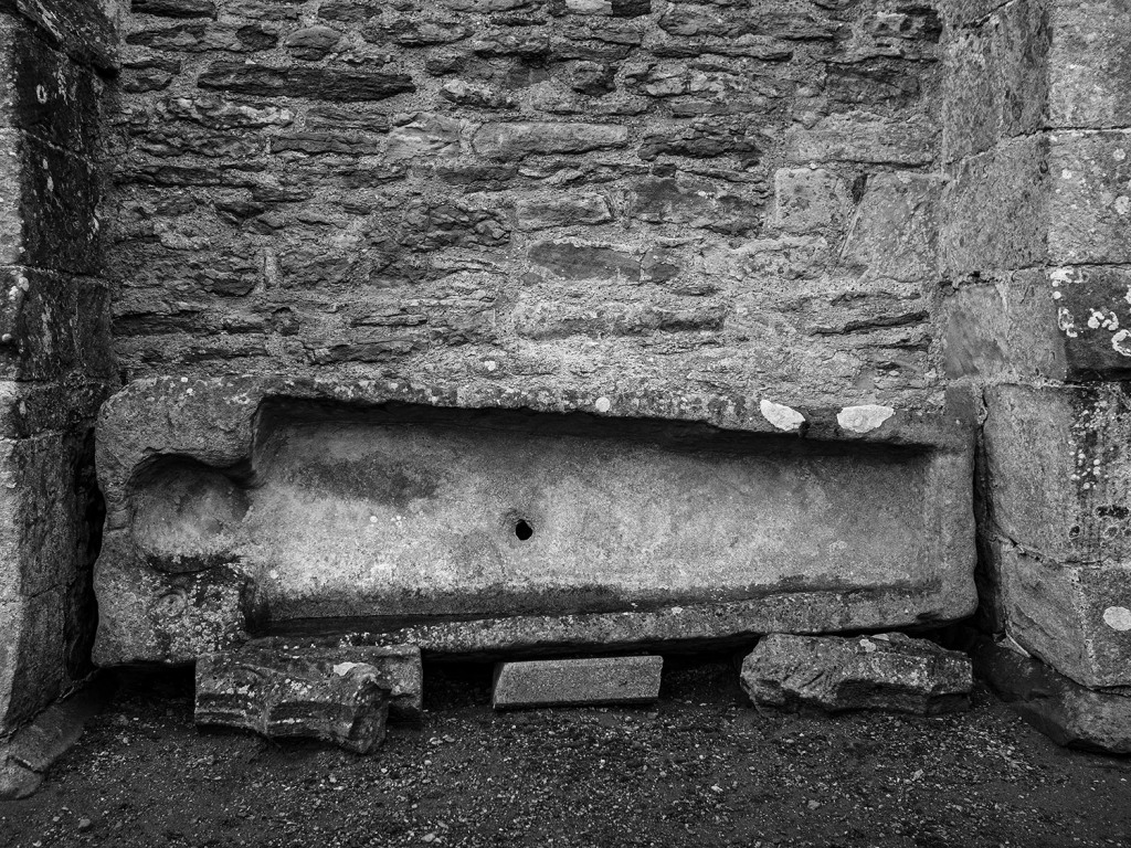
South of the large boundary earthwork we started to encounter many cairns, most are in deep heather and difficult to define, at least one of this group appears to be a large ruined barrow.
We continued south, traipsing through the deep heather to a grassy area containing a beautiful Platform Cairn. Platform Cairns are rare on the North York Moors, they are defined as, A roughly circular monument featuring a low, more or less level platform of stones surrounded or retained by a low stone kerb. Some may feature a small central open area, thus resembling a ring cairn. Source.
There is a large stone and hollow in the middle of the cairn implying a possible ruined cist, it is evident that this cairn had been excavated in the past. Graeme reminded me that we were only seven miles from Pickering, once home to James Ruddock.
James Ruddock was a nineteenth century commercial barrow digger. Between 1849 and his death in 1859 he opened many of our moorland mounds in search of finds to sell to the gentleman collectors of his time. His main client was the antiquary Thomas Bateman, he also opened barrows for Samuel Anderson of Whitby.
Unfortunately Ruddock did not always keep precise notes regarding the locations of his diggings, many of his finds have ended up in our museums with vague labels such as, from a mound 6 miles north of Pickering.
Moving further south we encountered this lovely, fairly well-defined ring cairn.
On the south eastern flanks of the Rigg is a group of hollow ways, these are not considered to be prehistoric.
At the southern end of the Rigg is this orthostatic wall which contains many large stones, some of which appear to be buried into the ground. If the wall contained unburied stones it would be classed as a boulder wall. The walling is definitely not prehistoric but may contain stones from an earlier feature.
Not far from the walling is this three foot high standing stone, located within an area of low banks and cairns at the southern end of the Rigg.
Blakey Topping and Thompson’s Rigg are well worth a visit, There is a wealth of prehistoric remains to be seen within a relatively small area. The area is owned by the National Trust and is not managed for grouse so has a mixture of habitats, we saw plenty of birds including Skylarks, Snipes and what I think were a large flock of Fieldfares.
If you visit this lovely place, what you’ll undoubtably notice is that wherever you are on the moor, Blakey Topping is the dominant landscape feature. Graeme and I agreed that this beautiful hill probably had a deep significance to the original inhabitants of this area. A sacred hill? perhaps even a sacred landscape?
Resources
Early Man in North East Yorkshire. Frank Elgee. 1930
Orthostatic Field Walls on the North York Moors. D A Spratt. YAJ Vol. 60. 1988
Linear Earthworks of the Tabular Hills, Northeast Yorkshire. D A Spratt. 1989
Prehistoric and Roman Archaeology of North-East Yorkshire edited by D A Spratt. 1993
CBA Research Report 101: Moorland Monuments’ in The Brides Of Place: Cross-Ridge Boundaries Reviewed, B Vyner. 1995
Howe Hill is a prominent mound in the centre of the village. It was previously thought to be a Norman earthwork or Motte but is actually a prehistoric burial mound dating from the Late Neolithic period to the Late Bronze Age. The site is still marked on the modern maps as a Motte.
The barrow has a beautiful tree growing on it and sits upon a natural knoll that has been bisected by the main road into the village. The primary views from the barrow are to the west across the Vale of Mowbray to the distant Pennines.
There is a Norman connection with the village, the local church was rebuilt in the mid-nineteenth century contains a number of Romanesque carved stones including this lovely capital depicting foliate heads.
The Abbey at Whitby was one of the earliest Romanesque buildings to be erected in the North of England but my focus today was on the neighbouring church of St Mary. A while ago my friend Chris Corner posted a picture of a head carved on a capital within the church, so on a whim, I headed over the storm-battered moor road to see what I could find.
I’ve visited this church many times in the past but this was prior to my explorations of Early Medieval stonework, I wasn’t sure what to expect. The south door with its arch and carved spiral capitals lifted my spirits.
Inside the church I made my way between the beautiful box pews to the chancel arch. The arch is mostly hidden behind the upper level, the lord of the manor’s pew. There is a second arch over the entrance to the tower but this has been completely hidden behind the organ.
On the capital of the left hand arch is a carving of a head emitting unfurling foliage. This bears a striking resemblance to the ‘Green Man’ carving in Marske Church.
Marske
LivertonLythe
There are other foliate heads to be found locally at Easington, Liverton and Lythe .
Durham CastleKirklevingtonLong Marton
One of the capitals on the right hand side of the arch has a carved head with a star on either side. The star is not an uncommon motif on Northern English Early Medieval stonework.
There are other elements of early stone work to be found in and around this lovely church, coupled with the Abbey next door, it is a wonderful place to visit. For me, with the failing light and the howling gale of Storm Barra blowing across the clifftop, it was time to head for home.
The church at Kirklevington has been in existence since the early medieval period. The chancel is Medieval, the rest of the church was rebuilt during the nineteenth century. Many ancients stones were found during the rebuilding of the church and have been incorporated into the fabric of the church.
Inside the porch is the entrance arch to the church. The two orders are a bit of a hodge-podge of weathered stones. There are spirals carved onto the capitals and one has a carving of intertwined serpents which is quite hard to make out.
The Chancel Arch is much more satisfying. The left hand capital is beautifully carved with a man’s head, stars and spirals. Beside the capital is the carving of a lion. The capital on the right side is carved with a headless bird, beside it is a rather damaged carving that has been interpreted as an ox. There is a lovely booklet available at the church which informs us that these carving represent the four evangelists, Mark (lion), Mathew (the head), John (the bird), Luke (the ox).
There are quite a few Cross Slabs within the church. Cross slabs are difficult to date as they were used from the eleventh to the seventeenth century.
There are a number of stones embedded in the external walls including six chevroned stones which may have once formed part of an arch. I’m guessing these were left over from the rebuilding of the doorway arch.
This beautiful door handle is a nod to the ancient origins of the church.
Replica
A number of ancient carved stones were discovered during the rebuilding of the church. Many of the ancient cross fragments have been removed from the church and are currently being stored at the Preston Hall Museum, a few are on display. The stone below is part of a cross shaft and is probably my favourite local medieval stone. It is thought to depict the Norse god Odin and his two ravens Huginn and Muninn (thought and mind). Odin’s ravens would fly out into the world and report what they saw to Odin.
Why is Odin depicted on a christian cross?
The early medieval period was a time of transition from the Pagan religions of northern Europe to Christianity. Nothing was straightforward, Pagan kings would succeed Christian Kings and the Christian church itself was split between two traditions, the celtic church and the church of Rome.
It may seem odd to us to see pagan imagery on a Christian cross shaft but the people of the early medieval period would have recognised and understood this imagery. Odin would have been a familiar figure to not only the people of Scandinavian descent but also to people who’s ancestors had travelled to our area from northern Europe.
Odin was known in the Anglo Saxon world as Woden, perhaps Woden was also worshipped in our islands prior to the arrival of the Anglo Saxons. During the Roman occupation of Britain, the majority of the Roman army was comprised of Auxiliaries. These units were manned by soldiers from territories that had fallen to Roman conquest. The majority of the Auxiliaries in our islands were composed of men from northern Europe, lands where Woden was a primary deity.
The Roman tradition was not to suppress the local belief in the gods of the lands they were conquering, they would associate local gods with Roman gods who possessed similar attributes, Woden/Odin was associated with the god Mercury because of his role on guiding the dead to the afterlife. The Roman historian Tacitus wrote that the Northern European tribes worshipped Mercury. Wednesday (Wodin’s Day) is known in Latin as Mercurii dies (‘Day of Mercury’).
This carving has been interpreted as portraying the god Mercury, is in the church at Aldborough, the church is said to have been built on the site of a Roman shrine.
It’s an interesting aside to look at Odin and Jesus. Given the evidence, it is fairly safe to assume that Odin may have originated in an older, shamanic-based belief system, if we detach ourselves from our christian assumptions we may also see similar shamanic elements in the life of Jesus.
In becoming a shaman there is generally a requirement for a ritual death and rebirth. Odin achieved this by hanging himself on a tree, Jesus was hung on a cross and then descended into the underworld before being reborn. Whilst on the tree, Odin pierced himself with his spear, whilst Jesus was on the cross he too was pierced with a spear.
Shamans are generally wanderers who undertake spirit journeys, Odin famously wandered in search of enlightenment, Jesus wandered with his small group of followers throughout his later life, the bible records his forty day solo journey into the Sinai desert without food or water. Both Jesus and Odin possessed the ability to speak to and raise the dead, Odin using his magic, Jesus by miraculous means, magic by a different name?
Perhaps the people of the past saw these similarities too. The early Christian church was very different to the church of today, the early Christian world was a place of mystics, demons, miracles, monks and local saints, many of who may have previously followed a pagan tradition.
Odin is thought to have hung himself on Yggdrasil, the world tree. The Pagans of northern Europe also had a world tree, Irminsul. These trees may have had their origins in the shamanic tradition where they symbolised the shaman’s journey between realms. Perhaps the cross represented the same idea to the early christians, an axis between the realms of heaven, earth and the underworld.
Resources
Anglian & Anglo-Danish Sculpture in the North Riding of Yorkshire. W.G. Collingwood. YAJ Vol.19. 1907
Yorkshire A Gazetteer of Anglo-Saxon & Viking Sites. G Points. 2007
Romanesque Yorkshire. Yorkshire Archaeological Society Occasional Paper No.9 Rita Wood. 2012
Archaeological Trail. St Martin’s Church. Kirklevington. A pamphlet available from the church.
Yggdrasil Image – Oluf Bagge, Public domain, via Wikimedia Commons
Thanks to Gary & Kate for arranging access to their lovely church.
The Romanesque arch, weather-beaten but recognisable.
The ghost of a Beakhead
The Norman font, uncomplicated with a cable pattern below the rim.
A protection mark? A saltire scratched into the underside of the arch resembles similar motifs carved into the witch posts of the moorland villages.
An Anglo-Saxon crosshead.
Regarding the grooves on the porch wall behind the cross head. These grooves are found on many of the walls of old churches throughout Europe. Tradition has it that they were caused by medieval archers sharpening their arrow heads prior to Sunday archery practice. In some parts of the country these stones are referred to as ‘Arrow Stones’. This seems like a highly unlikely explanation, the nature of the grooves would probably only serve to blunt a blade rather than sharpen it
Another possible, and more likely explanation for the grooves, is that they were caused by people collecting grit and dust from the church for use in folk medicines and ritual preparations. Any part of the fabric of a consecrated building, including water from the roof, was thought to have curative powers for both people and their livestock. The practice of collecting materials from a church, to use as a cure for all manner of ills, has been documented across Europe.
There is an old house on Marske High Street that has similar grooves on its external walls. I was told that it was once a schoolhouse and the grooves were caused by pupils sharpening their slate pencils on the building walls. An alternative explanation is that perhaps these stones were recycled from a previous building such as St. Germain’s Church or the medieval manor house that once existed on the outskirts of the town.
This cross shaft is thought to be Anglo-Danish. There is also the remains of an Anglo-Danish Hogback grave cover in the porch but it is is very eroded and barely recognisable.
Osmotherley
Asmundrelac 1086 Domesday Book
‘Asmund’s clearing’…A hybrid formation with a Norse inflexion of the of the first element suggests very intimate association of the Norse and Anglian speech.
The Place-Names of the North Riding of Yorkshire by A.H. Smith 1928
We took a trip up to Hexham, I spent half an hour wandering around the Abbey. As you walk into the Abbey you are faced with a Roman Tombstone, discovered in 1881, it is a memorial to Flavinus, a standard bearer. The carving depicts Flavinus riding over, what I presume is, a native Briton, the victors boot planted on his victims backside. The triumphs of past conquests are often displayed our churches, it is rare to see a memorial depicting our own islands conquest and defeat.
The original Saxon church was built using stone from nearby Roman sites. The church has been attacked many times during raids by the Vikings and later the Scots.
To the left of the High Altar is the Leschman Chantry Chapel, containing the tomb of Rowland Leschman, Prior of the Abbey from 1480 to 1491. The carvings on the tomb are an absolute joy.