I recently spotted this stone leaning against the wall at Tocketts Mill. It puzzled me for a while, I had seen a picture of a similar stone but couldn’t remember where. Eventually I remembered, the wonderful Hidden Teesside website
The stone is the base of a Verjuice or Beam Press. Elizabeth Ogilvie writes
..Verjuice or Beam Presses which were used to produce a kind of acid apple vinegar known as verjuice made mostly from crab apples and used in cooking and medicine. The method of crushing the apples was simple. Crab apples were placed on the base stone, a weight was positioned on top and pressed down by means of a wooden beam wedged at one end into a hollow of a tree stump or groove cut into a stone wall.
An Illustrated Guide to Stone Antiquities on the North Yorkshire Moors. E Ogilvie. 1996
The Crab Tree
Another Cleveland usage is, when a mare foals to hang up ‘the cleansings ’ (the placenta) in a tree, preferably in a thorn or failing that a crab tree; the motive assigned being to secure ‘luck with the foal.’ Should the birth take place in the fields, this suspension is most carefully attended to, while as for the requirements of such events at the homestead, in not a few instances there is a certain tree not far from the farm-buildings still specially marked out for the reception of these peculiar pendants. In one instance lately, I heard of a larch tree so devoted, but admittedly in default of the thorn; the old thorn-tree long employed for the purpose having died out.
Again, a lamb that is dropped dead, or that dies while still very young, is customarily hung up in a tree—properly in a thorn, though any fruit or berry-bearing tree will do. In the last case under my notice, the tree was a rowan-tree or mountain-ash. In all these cases the same principle is, I think, beyond question involved. Certainly in the case of the mare the offering would originally have been to Odin; probably in all cases of suspension on a berry-bearing tree the same may be true.
J. C. Atkinson, N. & Q., 4th S., vol ii., pp. 556, 557.
In the past, Midsummer was celebrated the lighting of bonfires on the 23rd of June, St John’s Eve. The following Sunday, Head Sunday, was a popular day for visiting healing wells.
…midsummer fires, with their numerous ceremonies, the rubbing the sacred flame, the running through the glowing embers, the throwing of flowers on the fire, the baking in it and distributing large loaves and cakes, with the dance about it, remained village customs.
Forty Years in a Moorland Parish. J.C. Atkinson .1908
A recent online conversation with a friend re-sparked my curiosity about the Tank Road. It’s an area that I’ve visited many times over the years, I’ve always felt that it was an important place but I’ve never fully got to grips with it. So I decided to walk it and try to pull together a description of the area.
I’ve always known it as the Tank Road or Old Tank Road, presumably it got this name from when it was used as a Tank training ground during WWII. The road itself is only 3.5km long, it runs between the main north-south roads to Castleton and Danby. From east to west, the road starts on the main north-south road to Danby and then crosses Gerrick Moor, Tomgate Moor and Middle heads where it meets the Castleton Road at White Cross on Three Howes Ridge.
On walking the road it becomes apparent that it was a busy route in the past, there is evidence of a number of sunken trackways, following the line of the road and joining the road from other routes, this becomes more obvious when you look at the LIDAR images of the area.
Regarding the origins of the road itself. There have been two excellent books written on the trackways of the North York Moors, Old Roads and Pannierways in North East Yorkshire by Raymond H. Hayes and Trods of the North York Moors by Christopher P. Evans. Hayes regards the route as possibly part of the Pannierman’s Causeway from Castleton to Staithes. Evans thinks it is part of a trod from Liverton Moor to Commondale. I suspect this route may have its origins in Prehistory.
Walking from east to west.
The road starts at the bend of the road that runs from the A171 to Danby where there is a small parking area. I definitely would not recommend trying to drive along the road. The road crosses a number water courses, the boggy areas have been filled with building rubble, it’s not unusual to find parts of cars on the side of the road.
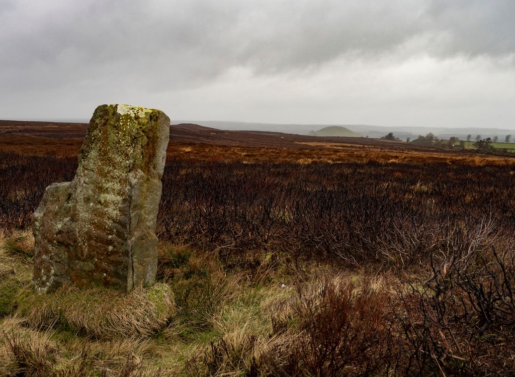
The most prominent monument at the start of the road is a large Barrow, one of a group known as Robin Hood’s Butts. Danby Beacon can be seen in the distance in the image above .
The next group of monuments lie just south of the road comprising of a barrow and an embanked circular feature known as an Enclosed Urnfield. The enclosure and barrow date to the Bronze Age. The enclosure was a place where the cremated remains of the dead were placed, often in small pottery vessels. This type of monument is quite rare, they are generally only found in Northern England and Southern Scotland. Only 50 examples are known, 3 of which are within a few minutes walk of the Tank Road.
Photographing many of these prehistoric monuments is quite difficult, most of them are fairly low-lying features, covered in heather on a heather moor. The vegetation is quite low at the moment so this is probably the best time of the year to visit and once you get you eye in they are not to difficult to spot. I’ve included a few Open Access LIDAR images as they give a better idea of the form of the monuments.
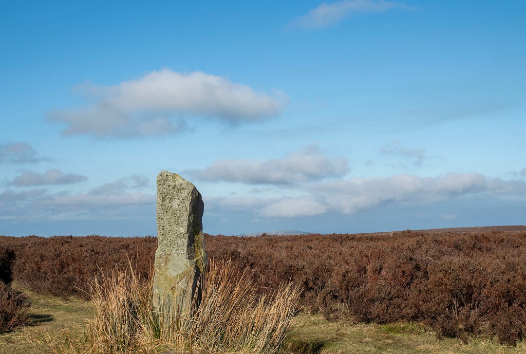
To the north of the road is a large standing stone. The stone is unusual as it is ‘L’ shaped and its surface has fossil ripple marks on its surface. There are no obvious outcrops of stone on this part of the moor, but there is an outcrop with similar ripple marks on the western flanks of Siss Cross Hill just under 2km away. Perhaps this was the source of the stone.
In the top image, behind the standing stone, you can see the large burial mound of Herd Howe in the middle distance and beyond that Freebrough Hill. Just below Herd Howe is an enclosure that dates to the Iron Age. I have previously written an account of the enclosure, Herd Howe and the nearby Cross Dyke.
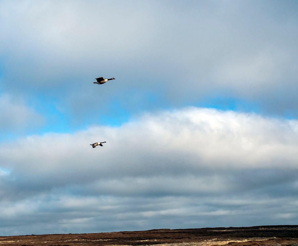
On my last two walks along the road I have seen quite a number of geese. I presume they are overwintering here. On my last visit this pair flew towards me honking, circled me and then headed back to Dimmingdale.
Leaving the road I followed a track south to have a look at Siss Cross. The cross is a crude unworked upright stone, it may be a replacement for the original cross. Running down the hill from the cross are a number of sunken trackways, perhaps the cross was a route-marker. Back in the 19th Century local Antiquarian J.C Atkinson discovered what he described as a flint tool making site just south of Siss Cross. He collected enough flint tools and debitage to fill ‘half a fair sized fishing basket’. The flint tools are thought to have been made by Mesolithic hunter gatherers. The site would have been a good place for a hunting camp, it is well drained and has a large viewshed, even on a muggy day I was able to look along the Esk Valley and make out the distinctive profile of the RAF site on Fylingdales Moor over 21km away.
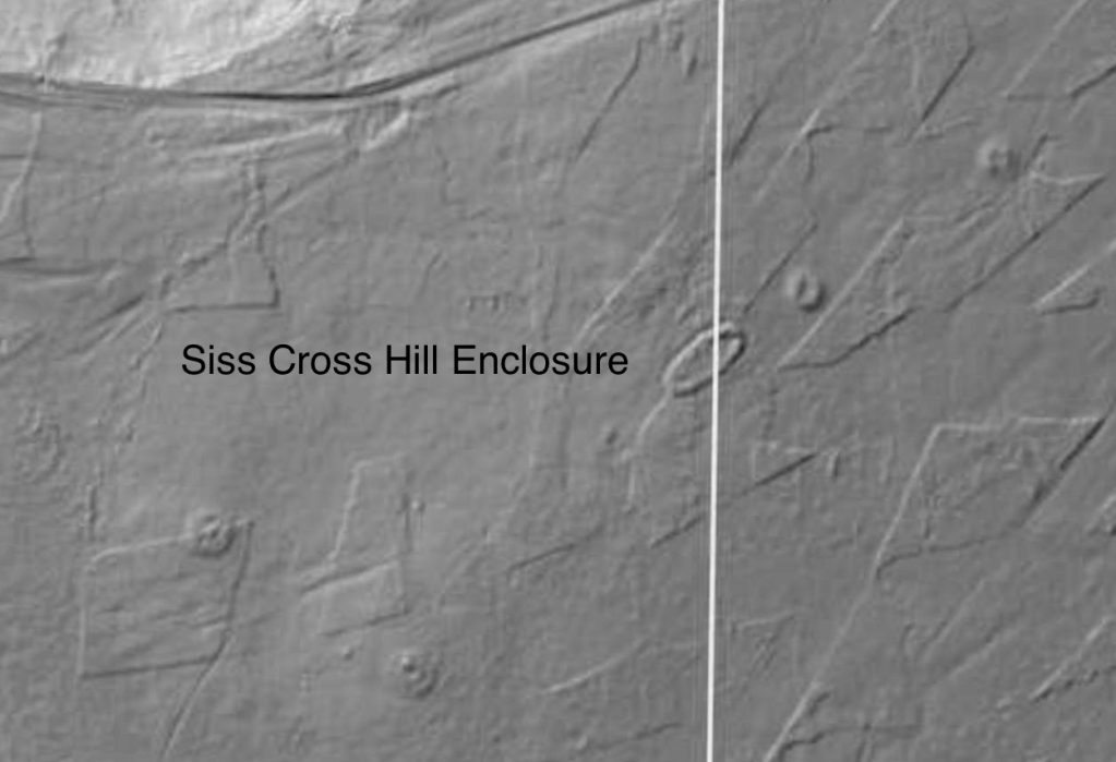
I headed back to the Tank Road via the Trig point on the top of Siss Cross Hill. There is another Enclosed Urnfield with associated Barrows here. Unlike the previous enclosure this one is oval in shape and quite large 38x20m. Interestingly, the enclosure and the two associated barrows are aligned on the western-most Barrow of the Robin Hood’s Butts group. This alignment is also roughly the direction of the Midsummer sunrise and Midwinter sunset. The enclosure is also intervisible with the third Enclosed Urnfield on Moorsholm Rigg.
I walked back onto the road from Siss Hill and followed it down into Ewe Crag Slack. The slack is a former glacial drainage channel and is generally quite boggy. The keepers and the farmer struggle to keep the road passable down here, the place is a jumble of boulders, concrete posts and deep muddy ruts.
Ewe Crag Slack is a significant location in the study of prehistory on the moors as it was one of a number of places where Paleoenvironmental pollen cores were taken from the peat and the sediments below it. The data from Ewe Crag helped provide evidence that the people who lived here during the Mesolithic period may have been actively managing the land. The pollen cores showed evidence of forest destruction and subsequent soil erosion, this combined with charcoal deposits suggests that people may have been creating forest clearings much earlier that was previously thought.
I noticed this boulder by the side of the road. The boulder has been broken but you can see that it’s original form was rounded. The rock type looks like a fine grained igneous rock, basalt or andesite. I presume it is a glacial erratic. It’s curious because less than a kilometre away, at Dimmingdale, is a barrow that was excavated in the 19th Century by J.C. Atkinson, the same antiquarian who found the Siss Cross Flints. Atkinson wrote that the barrow contained ‘blocks of basalt from the Cleveland Dyke’. It is possible that the stones came from the Cleveland Dyke, the nearest potential outcrop that I’m aware of is at Scale Cross 4.2km away, where it was quarried in the modern era. I wonder if the barrow stones may have originated closer to home as glacial erratics washed-down to Dimmingdale when the ice began to melt. One for further research.
Walking the final section of the road to White Cross my camera battery died. The final 2 images were taken when wandering the road in 2017, they are a Danby-Moorsholm guidestone & White Cross.
Gallow Howe was a large prehistoric burial mound located beside the moorland road that runs across the high moors connecting Eskdale with the Vale of Pickering. Today, there are no traces of the mound to be seen and it is no longer marked on the OS maps.
In 1863 R.C Atkinson, described the mound as a chambered cairn 7 – 8 feet in height and about 9 yards in diameter, with a kerb of stones standing 3-4 feet high around its base. On excavating the mound, an internal dry stone walled chamber or cist, 5 feet long 3 feet wide, was found. The excavator dug 5-6 feet down into the cist and found nothing.
Atkinson also tells us that there was a tradition that a gallows once stood on or near to the mound.
It’s unfortunate that large cairns close to roads were often used as convenient quarries for road menders and stone wallers. Today, the only trace of the site is a nearby stone carved with the name Gallow How, the stone is one of 25 erected along length of Castleton Rigg to mark the boundary between the Westerdale and Danby estates.
The site is intervisible with other large barrow groups along the Esk Valley margins including Danby Beacon which can be seen on the far right of the image above.
A lorry passing the site of Gallow Howe carrying moorland stone… there’s a metaphor here somewhere.
In her book, An Illustrated Guide to Stone Antiquities on the North Yorkshire Moors, Elizabeth Ogilvie wrote that the gallows was in use until around 1760 and that a gibbet* stood on the howe long after it was last used.
She also wrote that the Hand of Glory, which is now in the Whitby Museum, was alleged to have come from a corpse hanged on Gallow Howe.
Gallows sites were viewed as places of dread, inhabited by the lost souls of those executed, they were often located in liminal places. This site, a gallows built on top of a pagan burial mound, on an estate boundary, on an empty moor would have been seen and understood by everyone travelling to the dale. Two thousand years earlier, the Chambered Cairn may have been located here for similar reasons.
The site maintained its strategic value into the twentieth century. During the Second World War it was used by the Royal Observer Corps. During the Cold War an underground bunker was built on the site to monitor radiation levels during a nuclear attack. The bunker was abandoned in the 1990s and has recently been restored and can be visited on open days
* A gibbet was a cage or set of chains where the body of the hanged person was left to rot as a warning. The body was sometimes covered in tar to preserve it.
Sources
Map extract reproduced with the permission of the National Library of Scotland’
J.C. Atkinson. Traces of our Remote Ancestors The Gentleman’s Magazine Vol. 214. 1863
E. Ogilve. An Illustrated Guide to Stone Antiquities on the North Yorkshire Moors. 1996
I’ve been interested in the notion of boundaries recently so decided to combine this with a wander over Easington High Moor following the route of an eighteenth century perambulation that I found posted online a few years ago.
Manorial perambulations are an ancient practice, the boundaries of the district are walked to confirm ownership and ensure that no territorial infringements have taken place. What is interesting about this route is that it continues to be used as a formal boundary to define at least 13 different regional, county, unitary authority, parliamentary, and parish territories.
The route starts on the little-walked western section of the moor beside the Danby Road at a stone called Harlow Bush, the perambulation states that it is also called Harlot-Busk, Harlot-Thorn, otherwise Harlow-Thorn, otherwise High- Thorn.
The early OS map shows Harlow Bush and High Thorn as two separate stones. I was unable to find the latter stone but there has been much road widening since the map was drawn so the stone has either been removed or is lost in a mass of gorse and brambles at the junction between the Danby and Moors road. it doesn’t take the moor long to swallow-up the fallen.
A number of the stones have dates carved into them, mainly from the early 1800s and post-date the enclosure of the moor in 1817. The names of the perambulation sites imply that prominent stones and trees were used as boundary markers, this was formalised during the 19th century by the erection of many of the boundary stones that we see across the northern moors today. Some of them, especially the earth-fast stones, probably pre-date this period.
Others stand beside older stones and bear their names.
I cross a marshy section and come across a long section of cast iron pipe. The 40″ diameter pipe is a remnant from an attempt to build a railway across the moor. The railway, known locally as Paddy Waddell’s Railway, was supposed to be built to carry iron ore from the mines at Skelton and Brotton to the ironworks of Grosmont. The project was halted due to lack of funds and a recession in the iron trade
The Great Dinnod stone has fallen, beside it is a concrete post marked GT on one face and DT on the other. Further along the low ridge is the Little Dinnod, still standing.
Beneath the Great Dinnod ridge is a beautiful low grassy valley, it’s a marked contrast to the heather moorland that surrounds it. The valley terminates at the Mellowdale Slack. As I walk along the slack, dozens of tiny birds fly out around me and land in the trees. It’s a magical place. I stop and sit in the shade of a beautiful Rowan listening to the chirruping birds and watch dragonflies busying themselves along the valley.
Refreshed, I climb up onto Middle Rigg to have a look at a form of Prehistoric boundary marker, a Segmented Pit Alignment or SEPA. Double pit alignments have been found in other parts of our islands but this particular class of monument is unique to the North York Moors. This definition is taken from the excellent official blog for the North York Moors National Park
A SEPA earthwork however is made up of two or three pairs of pits inside two parallel enclosing banks largely made from the spoil from the pits, these are generally in what appear to be conjoined segments. The segmentation suggests development over time rather than a linear structure created in one go as a land boundary.
In each case the SEPAs appear to be aligned with nearby Bronze Age barrows (burial mounds), which suggest the SEPA are Bronze Age too and could have had a related ritual purpose. The alignment of all the SEPAs is north-west to south-east. This alignment seems to have taken precedence to any alignment with the barrows. The parallel banks were oddly low, which means the earthworks were not prominent in the landscape when they were constructed, unlike the barrows.
Most of the pits are filled with grasses and sedges, the low enclosing banks are visible where the heather has been burned-off.
One of the pits has an excavation trench running across the pit and bank. This may have been left from Canon Atkinson’s 1848 excavation where he interpreted the pits as the remains of an ancient British pit village.
There is another line of pits close to the SEPA, this has a much more recent history and has nothing to do with boundaries. The LIDAR image above shows the pit alignments and barrows of Middle Rigg. It also shows a curving line of four pits, these are bomb craters caused by the dropping of bombs during a Zeppelin raid on the North Eastern coast in May 1916. A full account of the raid can be read here
I walk over the rigg to the Long Stone. This beautiful monolith with it’s strange disc is probably one of the tallest stones of the Northern Moors and is one of my favourites. Is it prehistoric? I don’t know but would like to think so. It is also a fitting end point for my wander across this section of this lovely moor.
Sources
Maps and Lidar image reproduced with the permission of the National Library of Scotland
When I dee, for dee I s’all, mind ye carry me to my grave by t’church-road
Street Lane – Water (Great Fryup Beck) -Long Causeway Road – Nun’s Green Lane – High Gill – Fairy Cross Plain – Water (Little Fryup Beck) – Stonebeck Gate Lane – Slate Hill – Church Way – Danby Rigg – Tofts Lane – Crossroad – St. Hilda’s Church
Should the family of the departed one possess a hive, the announcement of a death must at once be made to the bees, and the hive be draped in black. The bees must also have given to them a portion of everything, to the minutest detail, which is offered to the bidden guests, including wine, spirits, tobacco, and pipes; nothing must be omitted, for in some undefined way bees watch over the welfare of those to whom they belong, and it would be unwise to offend them. It is held that if the first swarm following a death, no matter how long the interval, is easy to hive, success is guaranteed for the next business transaction, but should the swarm settle on a dead bough, it foretells death to another of the family in the near future; while should the swarm fly away and be lost, then great care must be exercised in all undertakings, until such times as a swarm has been successfully hived.
Yorkshire Wit, Character, Folklore & Customs. R Blakeborough. 1911
Rev. Atkinson tells of the bees being put into mourning at the death of their master, this account was given to him by the rector of Sessay.
..Presently his attention was aroused by the passage of a woman, the wife of the eldest son of the deceased man. She was carrying a tray, on which he saw there were piled a variety of eatable and drinkable matters. She went straight to the beehive, and he heard her address the bees themselves. Naming the late owner, she said, “John G____ is dead, and his son is now master. He has sent you something out of every dish and jug on the table, and we hope you will be content to take him as the new master.”