Tank Road II

A recent online conversation with a friend re-sparked my curiosity about the Tank Road. It’s an area that I’ve visited many times over the years, I’ve always felt that it was an important place but I’ve never fully got to grips with it. So I decided to walk it and try to pull together a description of the area.

I’ve always known it as the Tank Road or Old Tank Road, presumably it got this name from when it was used as a Tank training ground during WWII. The road itself is only 3.5km long, it runs between the main north-south roads to Castleton and Danby. From east to west, the road starts on the main north-south road to Danby and then crosses Gerrick Moor, Tomgate Moor and Middle heads where it meets the Castleton Road at White Cross on Three Howes Ridge.

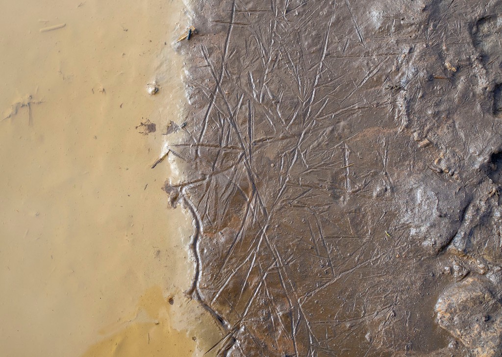
On walking the road it becomes apparent that it was a busy route in the past, there is evidence of a number of sunken trackways, following the line of the road and joining the road from other routes, this becomes more obvious when you look at the LIDAR images of the area.

Regarding the origins of the road itself. There have been two excellent books written on the trackways of the North York Moors, Old Roads and Pannierways in North East Yorkshire by Raymond H. Hayes and Trods of the North York Moors by Christopher P. Evans. Hayes regards the route as possibly part of the Pannierman’s Causeway from Castleton to Staithes. Evans thinks it is part of a trod from Liverton Moor to Commondale. I suspect this route may have its origins in Prehistory.

Walking from east to west.

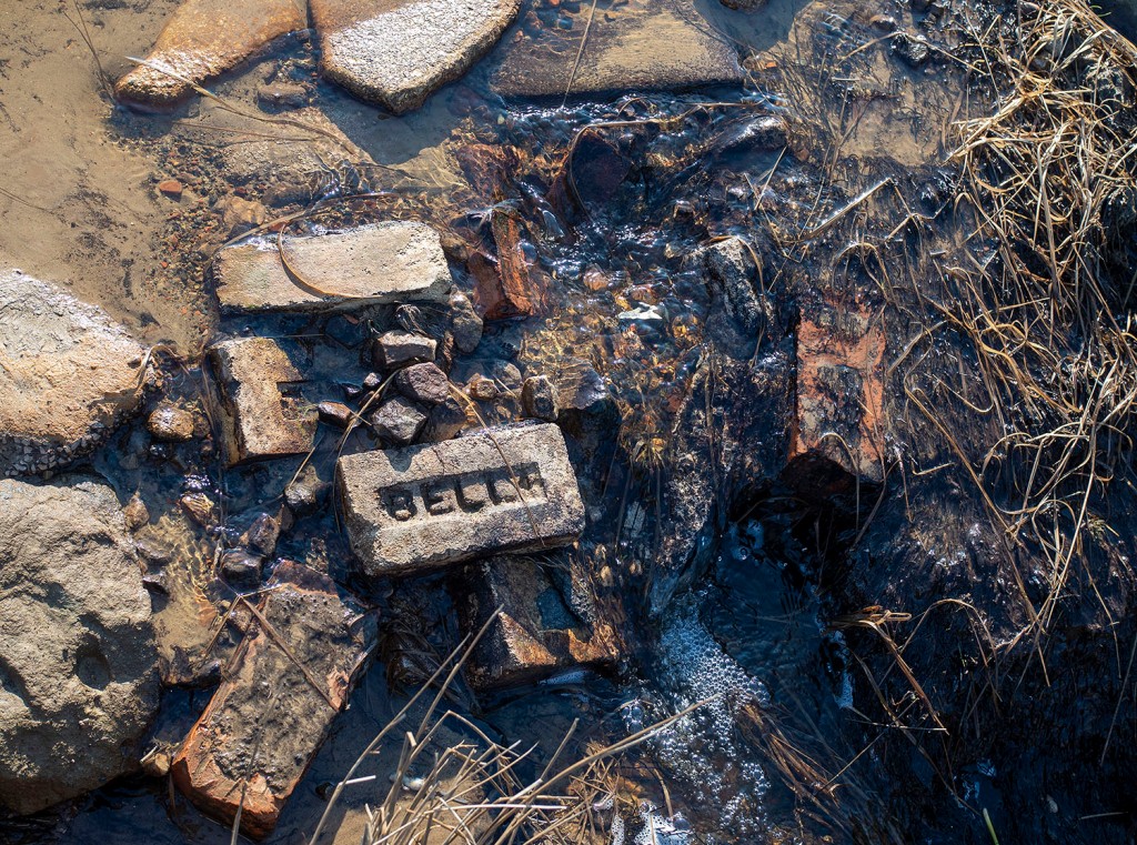
The road starts at the bend of the road that runs from the A171 to Danby where there is a small parking area. I definitely would not recommend trying to drive along the road. The road crosses a number water courses, the boggy areas have been filled with building rubble, it’s not unusual to find parts of cars on the side of the road.

The most prominent monument at the start of the road is a large Barrow, one of a group known as Robin Hood’s Butts. Danby Beacon can be seen in the distance in the image above .

The next group of monuments lie just south of the road comprising of a barrow and an embanked circular feature known as an Enclosed Urnfield. The enclosure and barrow date to the Bronze Age. The enclosure was a place where the cremated remains of the dead were placed, often in small pottery vessels. This type of monument is quite rare, they are generally only found in Northern England and Southern Scotland. Only 50 examples are known, 3 of which are within a few minutes walk of the Tank Road.

Photographing many of these prehistoric monuments is quite difficult, most of them are fairly low-lying features, covered in heather on a heather moor. The vegetation is quite low at the moment so this is probably the best time of the year to visit and once you get you eye in they are not to difficult to spot. I’ve included a few Open Access LIDAR images as they give a better idea of the form of the monuments.

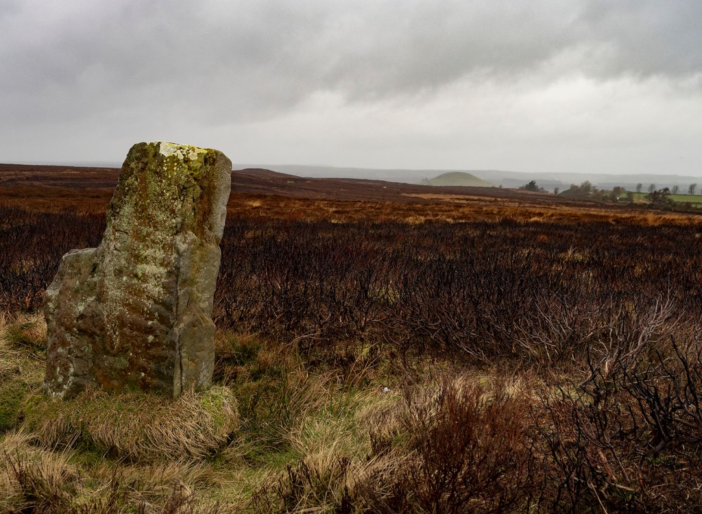
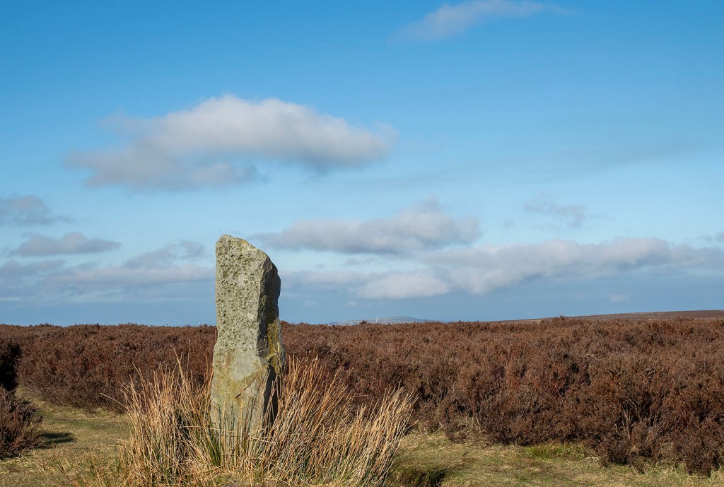
To the north of the road is a large standing stone. The stone is unusual as it is ‘L’ shaped and its surface has fossil ripple marks on its surface. There are no obvious outcrops of stone on this part of the moor, but there is an outcrop with similar ripple marks on the western flanks of Siss Cross Hill just under 2km away. Perhaps this was the source of the stone.

In the top image, behind the standing stone, you can see the large burial mound of Herd Howe in the middle distance and beyond that Freebrough Hill. Just below Herd Howe is an enclosure that dates to the Iron Age. I have previously written an account of the enclosure, Herd Howe and the nearby Cross Dyke.

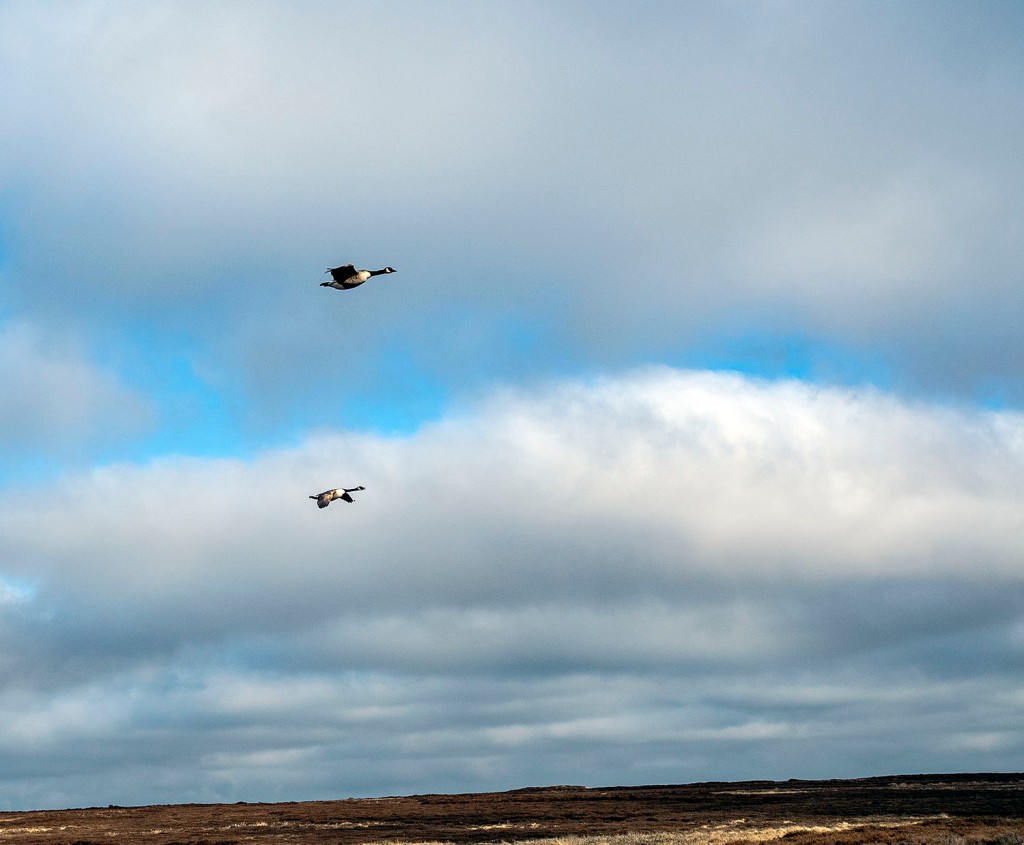
On my last two walks along the road I have seen quite a number of geese. I presume they are overwintering here. On my last visit this pair flew towards me honking, circled me and then headed back to Dimmingdale.

Leaving the road I followed a track south to have a look at Siss Cross. The cross is a crude unworked upright stone, it may be a replacement for the original cross. Running down the hill from the cross are a number of sunken trackways, perhaps the cross was a route-marker. Back in the 19th Century local Antiquarian J.C Atkinson discovered what he described as a flint tool making site just south of Siss Cross. He collected enough flint tools and debitage to fill ‘half a fair sized fishing basket’. The flint tools are thought to have been made by Mesolithic hunter gatherers. The site would have been a good place for a hunting camp, it is well drained and has a large viewshed, even on a muggy day I was able to look along the Esk Valley and make out the distinctive profile of the RAF site on Fylingdales Moor over 21km away.

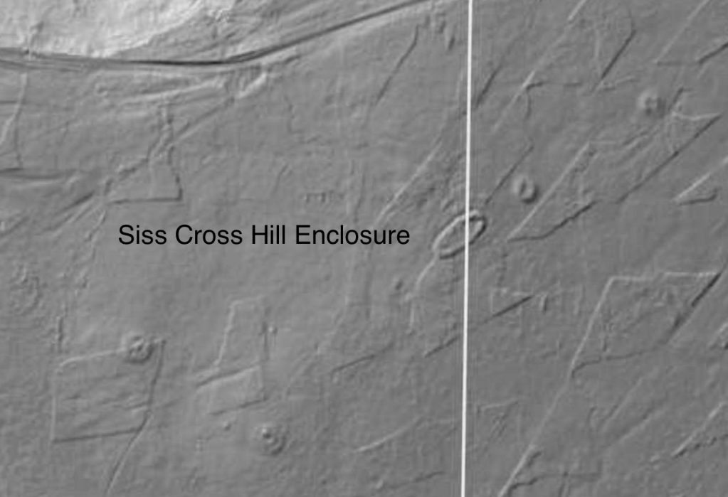
I headed back to the Tank Road via the Trig point on the top of Siss Cross Hill. There is another Enclosed Urnfield with associated Barrows here. Unlike the previous enclosure this one is oval in shape and quite large 38x20m. Interestingly, the enclosure and the two associated barrows are aligned on the western-most Barrow of the Robin Hood’s Butts group. This alignment is also roughly the direction of the Midsummer sunrise and Midwinter sunset. The enclosure is also intervisible with the third Enclosed Urnfield on Moorsholm Rigg.

I walked back onto the road from Siss Hill and followed it down into Ewe Crag Slack. The slack is a former glacial drainage channel and is generally quite boggy. The keepers and the farmer struggle to keep the road passable down here, the place is a jumble of boulders, concrete posts and deep muddy ruts.

Ewe Crag Slack is a significant location in the study of prehistory on the moors as it was one of a number of places where Paleoenvironmental pollen cores were taken from the peat and the sediments below it. The data from Ewe Crag helped provide evidence that the people who lived here during the Mesolithic period may have been actively managing the land. The pollen cores showed evidence of forest destruction and subsequent soil erosion, this combined with charcoal deposits suggests that people may have been creating forest clearings much earlier that was previously thought.

I noticed this boulder by the side of the road. The boulder has been broken but you can see that it’s original form was rounded. The rock type looks like a fine grained igneous rock, basalt or andesite. I presume it is a glacial erratic. It’s curious because less than a kilometre away, at Dimmingdale, is a barrow that was excavated in the 19th Century by J.C. Atkinson, the same antiquarian who found the Siss Cross Flints. Atkinson wrote that the barrow contained ‘blocks of basalt from the Cleveland Dyke’. It is possible that the stones came from the Cleveland Dyke, the nearest potential outcrop that I’m aware of is at Scale Cross 4.2km away, where it was quarried in the modern era. I wonder if the barrow stones may have originated closer to home as glacial erratics washed-down to Dimmingdale when the ice began to melt. One for further research.

Walking the final section of the road to White Cross my camera battery died. The final 2 images were taken when wandering the road in 2017, they are a Danby-Moorsholm guidestone & White Cross.

Resources

Lidar Maps – Open Data Maps

Old Roads and Pannierways in North East Yorkshire by Raymond H. Hayes. 1988

Trods of the North York Moors by Christopher P. Evans. 2008

Early Man in North-East Yorkshire by Frank Elgee. 1930

Excavated Bronze Age Burial Mounds of North East Yorkshire by M.J.B Smith. 1994

Along The Esk. A Guide to the Mining Geology of the Esk Valley by Denis Goldring. 2006

A contribution to the late quaternary ecological history of Cleveland, North-East Yorkshire by R.L. Jones

Historic England

Lealholm Moor

2

I took a walk from Danby Beacon to Lealholm Moor to have a look at a Ring Cairn that I had recently read about.

1

The wide track from the Beacon is made of slag, the slag would probably have been brought from the furnaces of Teesside during the early days of WWII when a large radar installation was built on the moors. Ironstone travelling from Rosedale and the Esk valley down to the furnaces of Teesside with iron-rich slag returning to the moors.

1

A rainstorm blows into Great Fryup Dale from the high moors

1

The storm tracks along the Esk valley, the sun briefly follows behind.

1

At the side of the track a gorse bush has grown a hedge around its base, a prickly windbreak for itself and the moorland sheep

1

On the rigg the thin moorland soils offer little, this is compounded by the regular burning and draining of the moors, ensuring that very little apart from heather and a few grasses can thrive. In times of increasing climate instability and the loss of native species, the management of grouse moors is coming under increasing pressure to change its ways.  Stanhope White once called the moors ‘a man made desert’.

2

A moorland cross base and cradle, the remains of Stump Cross. The cross was located at the junction of 2 medieval trackways, Stonegate and Leavergate.

The cross base sits at the foot of Brown Rigg Howe, a Bronze Age Round Barrow located on a small hill. The barrow is intervisible with a number of other prehistoric monuments including mounds on the other side of the Esk Valley.

1

On top of the barrow is a steel plate, a base plate of a military searchlight, used for guarding the nearby Radar station during WWII.

ironstone-axe-bladeThe Brown Rigg barrow was opened by Canon Atkinson of Danby, he found a cremation burial and a stone axe made of basalt. A number of stone axes have been found locally including one made from Ironstone, it is now in the Whitby Museum.

1

Rabbits have made the mound their home, their paths revealed where the heather has been burned-off.

2I walk on to the next barrow, a gamekeeper cruises by in his large 4×4. The keepers work for the Baron of Danby, Viscount Downe owner of the Dawnay Estate. The Dawnay estate website states that the Barons ancestors came from Aunay in Normandy. I would like to think that a number of my ancestors lie beneath the earth and stone mounds of the moors.

1

I arrive at the Ring Cairn. As with most surviving North Yorkshire moorland Ring Cairns there is very little to be seen, the 14 meter diameter ring can just be made out in the heather.

What draws me to these places is not necessarily the physical remains of the monuments but the opportunity to walk and observe their viewsheds, seeing how they sit in the landscape and speculate on their relationship with the many other prehistoric monuments of the area. Lines of mounds running across the moors and along the coast, marking the trackways and territories of our ancestors.

MAP

intervisibility/alignment – monuments – invasion beacons – radar stations – trackways

axe – ironstone – scoria

A great article on the WWII radar site at Danby Beacon http://liminalwhitby.blogspot.com/2012/12/danby-beacon.html

Heather Burning Article Yorkshire Post March 2020 

The Rock Art of the Kerb – Postscript

I bought my copy of Ronald Morris’s The Prehistoric Rock Art of Galloway & the Isle of Man in the 1990s from a second hand bookseller in Dundee. The flyleaf of the book has the name Kennedy McConnell and the date October 1982 inscribed on it.

On researching the previous owner I found this WW2 People’s War 

It makes me wonder if his war time work with Alan Turing’s team of cryptographers had left him with any insights into interpreting the meaning of Prehistoric Rock Art.

Kildale Moor

Kildale Enclosure

A Bronze Age cremation cemetery, enclosed by a bank of earth and stones surviving as an earthwork on the highest point of Kildale Moor. The cemetery measures 15m by 16.5m internally with an maximum wall height of 0.4m. The centre has been mutilated by excavation in 1941 and the wall in the east has been cut through by an excavation trench now refilled. The feature is partially visible on air photographs and was mapped as part of the North York Moors NMP. It is not possible to determine the latest evidence for the feature due to dense vegetation cover on the 2009 vertical photography. Pastscape

fox hole

Predators are prey

Remnants

DSC_0189

A lone conifer thrives until the next burning

Signing the land

 A broken ring buried in the heather

Intervisible

Fetish


Wandering in land of the divine Hag

It all started a few years ago when I was studying a map drawn by Robert Knox. Knox’s map was published in 1849 and titled; A map of the country round Scarborough, in the North & East Ridings of Yorkshire : from actual trigonometrical survey with topographical geological and antiquarian descriptions / by Robert Knox, of Scarborough formerly marine surveyor to the East India Company, on the Bengal establishment. 

1849 Knox Map

What caught my eye was a stone at a junction of a number of tracks on Sneaton Low Moor called Old Wife’s Stone. This stone doesn’t feature on any subsequent maps and I couldn’t find reference to it in the modern literature. A few years ago I went looking for the stone and found nothing. My thoughts turned to it recently when it was announced that Sirius Minerals had been given permission to sink a mine at Sneaton. I knew that the road where the stone had been located would be used as an access road to the mine site and therefore, over time, could potentially be widened to take the heavy vehicles accessing the site. I decided to have another look for the stone before any improvement work took place.

As on my previous visits, the only stones I could find were a couple of upright stones that had probably once served as gateposts and a stone carved with a ‘C’ and an ‘X’ marking the boundary of the Cholmley estate, this boundary was also the Medieval boundary of the Whitby Abbey lands. Having found nothing, I decided to head out onto the moor and follow the track south along Shooting House Rigg.

Even in summer the moor here is boggy and is not particularly popular with walkers. Picking my way through the stands of low, gnarly pines I was visited by at least a dozen large, curious, iridescent dragonflies, none would stay still enough to be photographed. Standing in this low wood in a bog surrounded by these beautiful insects with the sea-fret blowing across the moor was a magical other-worldly experience.

One returning to the path, I noticed dozens of chirruping Stonechats perched upon the stone wall, as I approached they would fly on a few yards ahead of me, announcing my presence on the moor.

Boardwalk

A boardwalk has recently been built to help walkers cross a particularly boggy section, the bleached timber contrasted against the red grass gives the structure a sculptural feel, it also makes a very satisfying sound as you walk across it.

Decoy

The moor on this northern section was used as a bombing decoy site during WWII, these sites were known as QL Sites. The site  was comprised of rows of lights to give the impression of buildings and factories when seen from the air by enemy bombers . Amongst the QL sites were also Starfish Decoy Sites which simulated bomb damage by setting fires and producing smoke.  The remains of these sites can be seen on the ground as a series of low trenches, they are best appreciated on aerial photographs such as the one above.

Heading south I came to an empty stone socket, this is all that remains of John Cross, a Medieval moorland cross. The last time I was here there was a stone marked with the Cholmley ‘C’ stuffed clumsily into the base. This stone is now laying nearby. I also noticed another stone with a worked section that would fit into the socket and wondered if this could be the remains of the original cross. A few mason-cut stones poked through the turf indicating the location of the pedestal marked on the first OS map of the area, published in 1853.

1853 OS Map

I followed the path down to one of my favourite places on the North York Moors, The Cross Ridge Earthworks and the standing stones known as The Old Wife’s Neck.

1895 OS Map

In Archaeological terms the earthwork is classed as a Prehistoric Cross Ridge Boundary comprising an impressive series of three parallel banks and ditches running across a spur of land for almost a kilometer. To the west of the dykes is a large cairnfield, old maps also show cairnfields to the north and south of the dykes, much of which was probably destroyed by the multiple trackways across the moor coupled with clearances by the War Department  during WWII when the moor was used as a military training ground.

Update. Recent work by Archaeologist, Blaise Vyner, and his team, has suggested that there may have been far fewer cairns in this area and that the original OS surveyors may have been mistaken.

The site has a personal significance to me, it contains a pair of standing stones one of which is the Old Wife’s Neck. I consider this anthropomorphic megalith represents the Divine Hag of the North York Moors, The Old Wife, who is also known in the north of our islands as Carlin and Cailleach, a primal, supernatural being. I have written about the Old Wife/Cailleach elsewhere so I’ll not bore you with any more of my ranting here.

After spending a little time with The Old Wife I walked down to the wide deep valley of Biller Howe Dale Slack. The slack is a remnant from the last Ice Age, when it was formed by water overflowing from an ice dammed lake in the upper Iburndale valley.

Frank Elgee reported that hundreds of flint arrowheads were found in Biller Howe Dale and uses this as evidence for prehistoric warfare. I have followed up on Elgee’s source (The Gentleman’s Magazine 1857 ii 445-7) and there is no mention of the flint finds, the reference is actually to an article on the great Yorkshire antiquities forger Flint Jack.  During my visit I did find evidence of warfare in one of the erosion scars. Unfortunately it was modern warfare, remnants from when this part of the moor was used as a training ground during the preparations for the D-Day landings in 1944.

A handful of bullets

Sources

Maps maps.nls.uk

Aerial Photography zoom.earth

Cross-Ridge Boundaries on Fylingdales Moor: John Cross Rigg & Latter Gate Hills. Blaise Vyner. Prehistoric Yorkshire 58, 2021.

Postscript

On further researching the Old Wife’s Stone I found this passage in Robert Knox’s book Descriptions, geological, topographical and antiquarian in Eastern Yorkshire, between the rivers Humber and Tees.

Hannah Hagget

Saltburn by the Sea

Walking out of Hazelgrove into low autumnal sunshine and clear blue skies. There will probably be a frost tonight. Saltburn faces north, this is unusual for a coastal town.

A small flock of Pigeons live beneath the pier. The yearling Kittiwakes prefer to congregate close to the fish and chip shop. Crows scavenge the strand line.

   Cat Nab was once home to wild cats, a Bronze Age burial was discovered on its slopes. Victorian authors often described Huntcliff as majestic.

The sea wall is in part made of the stone sleepers from the world’s first passenger railway. Another part of the sea wall is an anti-tank wall built during World War II