Kettleness

A coastal walk with Graeme Chappell

Kettleness – Cat Beck – Randy Bell End – Hob Holes – Runswick Sands – White Stones – Redscar Hole – Hill Stones – Kettleness Sand – Kettleness Scar – Wind Hole – Long Sand – White Shoot – Maiden Wyke – Lucky Dogs Hole – Kettleness Alum Works

The Fairies long gone, the sound of Claymoor battledores no long ring over Runswick shores.

Hob has flit, kink coughs go untreated.

A whale lays headless and rotting on the rocks at White Stones. The stench of death and decay is all around, even the gulls avoid this place. We push on, scrambling over rocks, mouth breathing.

17th of December 1829. The village and Alum Works of Kettleness slid down the cliff to the sea. No lives were lost. The village and works were swiftly rebuilt.

Ore was gathered from these beaches when Teesside furnaces were still an idle dream.

Iron returns to its source, the sea reclaims its own

Shap Granite, batholith born, ice borne.

The sun is shining, we are bold.

We wade through whin following a cliff-top path to the Alum Works, we watch Gannets. A very good day.

Cattersty

Escaping the crowds of Saltburn we headed to Cattersty Sands. Skinningrove has none of the seaside amusements of it’s neighbour so sees far less visitors, what it does have is a beautiful beach and a very good fish and chip shop which sadly was closed today.

Iron was mined here before the discovery of the main seams in the hills at Eston and prior to mining, iron-rich stone was collected from the beaches at Hummersea. An ironworks was established above the town in the late nineteenth century to process the local iron ore with coal and limestone imported from County Durham. The slag from the furnaces was poured onto the cliffs and also used as a building material in and around the village. The cliffs are an impressive site and are now home to nesting Fulmars and Jackdaws.

The names Cattersty, Hummersea and Skinningrove are all Scandinavian in origin. The cliffs to the south of the village are the highest on the east coast. Archaeologist Dr. Steve Sherlock’s work at nearby Street House has revealed evidence of occupation since at least 3900BC.

The Skinningrove/Loftus area does not see a great many visitors compared to other parts of our district but it has a fascinating landscape and rich history, all well worth seeking out. If none of this interests you and you just fancy a walk on a mile of so of beautiful uncluttered beach I’d recommend a trip to Cattersty.

If you want to learn more about Dr. Sherlock’s work at Street House there is a video here of him giving an online lecture at the Royal Archaeological Institute.

Slapewath

Lockdown walking

The terrier is quite old now, he is happy enough but his days of traipsing across moors have come to an end. The path between Slapewath and Boosbeck is ideal for him, it runs along the bed of an old railway built to service the local ironstone mines. The path is wide with no inclines, just right for a half blind, half deaf border terrier who likes to do things in his own time.

Slapewath is a strange place, at first glance it looks fairly rural but peer into the woods and along the tracks you’ll see scrap and storage yards, workshops and plant yards, most built over old ironstone mining sites. During the nineteenth and early twentieth centuries at least half a dozen mines operated locally, extracting ore to feed the furnaces of Teesside.

Ironstone wasn’t the first extractive industry to leave its scars on this valley. Jet has been quarried from the escarpment edges for millennia, jet is only found in this corner of North Yorkshire and was highly prized by our prehistoric ancestors. Beautifully carved jet objects have been found in high-status prehistoric burials throughout our islands.

Another industry that left its mark on the local landscape was alum production. During the seventeenth century, thousands of tons of rock were quarried and processed to produce alum.

The pathway is very muddy in places, local footpaths have taken a hammering during lockdown. Beneath the footpath is a tunnel /culvert. It’s empty apart from some beer cans and a pair of knee-high ladies boots.

With the summer foliage gone, it is possible to get a better view of the remnants of Carr’s Tilery at Margrove.

Slape Wath – Slippery Ford’ from ON sleipr and vao

Aysdale Gate – Asi’s valley’ from ON Asi and dael

Lealholm Moor

2

I took a walk from Danby Beacon to Lealholm Moor to have a look at a Ring Cairn that I had recently read about.

1

The wide track from the Beacon is made of slag, the slag would probably have been brought from the furnaces of Teesside during the early days of WWII when a large radar installation was built on the moors. Ironstone travelling from Rosedale and the Esk valley down to the furnaces of Teesside with iron-rich slag returning to the moors.

1

A rainstorm blows into Great Fryup Dale from the high moors

1

The storm tracks along the Esk valley, the sun briefly follows behind.

1

At the side of the track a gorse bush has grown a hedge around its base, a prickly windbreak for itself and the moorland sheep

1

On the rigg the thin moorland soils offer little, this is compounded by the regular burning and draining of the moors, ensuring that very little apart from heather and a few grasses can thrive. In times of increasing climate instability and the loss of native species, the management of grouse moors is coming under increasing pressure to change its ways.  Stanhope White once called the moors ‘a man made desert’.

2

A moorland cross base and cradle, the remains of Stump Cross. The cross was located at the junction of 2 medieval trackways, Stonegate and Leavergate.

The cross base sits at the foot of Brown Rigg Howe, a Bronze Age Round Barrow located on a small hill. The barrow is intervisible with a number of other prehistoric monuments including mounds on the other side of the Esk Valley.

1

On top of the barrow is a steel plate, a base plate of a military searchlight, used for guarding the nearby Radar station during WWII.

ironstone-axe-bladeThe Brown Rigg barrow was opened by Canon Atkinson of Danby, he found a cremation burial and a stone axe made of basalt. A number of stone axes have been found locally including one made from Ironstone, it is now in the Whitby Museum.

1

Rabbits have made the mound their home, their paths revealed where the heather has been burned-off.

2I walk on to the next barrow, a gamekeeper cruises by in his large 4×4. The keepers work for the Baron of Danby, Viscount Downe owner of the Dawnay Estate. The Dawnay estate website states that the Barons ancestors came from Aunay in Normandy. I would like to think that a number of my ancestors lie beneath the earth and stone mounds of the moors.

1

I arrive at the Ring Cairn. As with most surviving North Yorkshire moorland Ring Cairns there is very little to be seen, the 14 meter diameter ring can just be made out in the heather.

What draws me to these places is not necessarily the physical remains of the monuments but the opportunity to walk and observe their viewsheds, seeing how they sit in the landscape and speculate on their relationship with the many other prehistoric monuments of the area. Lines of mounds running across the moors and along the coast, marking the trackways and territories of our ancestors.

MAP

intervisibility/alignment – monuments – invasion beacons – radar stations – trackways

axe – ironstone – scoria

A great article on the WWII radar site at Danby Beacon http://liminalwhitby.blogspot.com/2012/12/danby-beacon.html

Heather Burning Article Yorkshire Post March 2020 

Huntcliff

The Mortuary house was built to store bodies that had been washed up by the sea, prior to this bodies were stored in the nearby pub. The building was sandwiched between the Lifeboat house and the Rocket Brigade house, both of which have been demolished.

The people of the Bronze Age buried their dead on Warsett Hill.

Walking the field margins dreaming of axe blades and scrapers. The cliff top fields are littered with the remnants of Teesside’s second Iron Age.

The cliff edge creeps ever closer, the sea will eventually take the railway, just as it took the Roman signal station that was once on the edge of Huntcliff.

The Guibal fan house was built to ventilate the cliff top ironstone mine.

Slapewath Spa

In 1841 Dr. Augustus Bozzi Granville published a three volume series of books titled The Spas of England and Principle Sea Bathing Places. They are beautiful books, describing Granville’s tour through England and documenting life at the end of the Regency Era.

spas

Granville was a fascinating character who led a full and colourful life.  ‘It has been the experience of few to see in their youth Napoleon Bonaparte in Milan, or as a medical student to witness the early experiments in electricity by Volta in Pavia, or to hear in Malaga the distant boom of the guns at the battle of Trafalgar, or as a postgraduate doctor in Paris to be present at Laennec’s invention of the stethoscope. Yet all of these events, and much else, occurred in the colourful life of Augustus Bozzi Granville, who was born 200 years ago in 1783. He is not now remembered for any major medicoscientific discovery, but during the ninety years of his eventful life his quicksilver personality had an impact on many fields..’  Alex Sakula.  His interest in spas stemmed from his desire, as a medical doctor, to improve public sanitation, he was a great advocate of sea bathing and spas as a means of restoring health.

Granville’s tour of our region begins with a visit to the spas at Croft and Dinsdale. He then travels to Stockton and comments on the rise of the new town of Middlebrough and its four thousand inhabitants. Granville is full of praise for Middlesbrough but does not hold back in criticising Stockton and its people.. ‘squalid and ill-dressed, discontented and not well-looking.’ Granville’s low opinion of the citizens of Stockton may have been coloured by the political and social upheavals that were happening at the time, he writes ‘The people at Stockton must have been inclined to the dolce far niente when they turned chartists, shortly before the time of my visit, and set about grumbling in good earnest, wandering in groups, the very picture of indolence and wretchedness.’

guisbro

Granville leaves Stockton and its grumbling Chartists and travels to Guisborough. He describes the journey from Stockton to Guisborough as one of the richest treats in England to the lover of landscapes. The purpose of his journey is to visit the spa on the road to Slapewath.

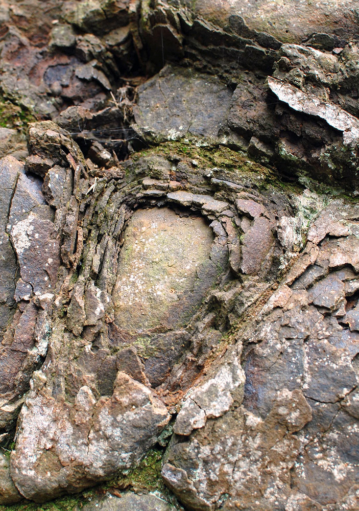
After a drive of a mile and a half on the south-east road from Guisborough, skirting the lesser Cleveland hills, my friendly companion and I entered a narrow carriage-way, which presently plunged abruptly into a thick and intricate wood. Following here a very tortuous path, hardly wide enough for a two-wheel carriage, and keeping along the brink of a murmuring beck on an alum-shale-rock bed, noisy and turbulent, we reached at length a most romantic and rocky nook, enlarged from what nature had made it by former alum-miners, but most solitary and retired.

At a spot where the torrent sweeps along a projecting mass of slatey rock, by the side of which it has   scooped out its own shallow channel, and under impending portions of the rocks which hang over   from the opposite bank, a stream of the most beautiful and transparent water is seen to spout immediately from the shale strata, and being conducted through a stone pipe, issues conveniently for the use of the drinkers. The taste is slightly sulphuretted, as is its smell; but this removed (and nothing is so easy) the water tastes as sapid as pure spring water. Perhaps after a little while, and on reflection, one can fancy the presence of a little of the bitterness of muriate of lime, but such a taste is very faint indeed.

The stream flows at the rate of thirty pints in a minute; its temperature was 50°, while that of the air was 63°. It is probable that while the alum-works (now wholly abandoned) were rife in this secluded spot, which can boast of having been the place where alum was first manufactured in England in Elizabeth’s time, the workmen may have noticed this water; but its introduction to public attention was due to the Rev. James Wilcocks, as I before observed, and is of as recent a date as 1822. Since then, it has acquired a certain degree of local celebrity. A rude bath-room for using the water, either as a cold or a hot bath, has been erected under the rock, and during fine weather a woman attends from Guisborough to supply the wants of the visitors.

The approach to, and situation of, this spring, are the most romantic I ever beheld in England. Its vicinity, also, to Redcar, as well as Whitby on the coast, besides a multitude of country-seats of great importance by which it is surrounded, invest the place with much additional interest. It will not, however, become very readily a fashionable Spa, there being many difficulties to overcome for that purpose, many wants to be supplied, and improvements to be suggested. Around the spring the fractured shaly-rock is covered with aluminous efflorescence.

John Walker Ord visited the spa site in 1844. Ord’s comments reflect the changing times, where Granville belittles the Chartists, Ord slates the ‘pseudo-Christians, perhaps he was attacking the moral sensibilities of the Nonconformist and Dissenter movements, both of whom were active in the 1840’s.

Ord’s description of the Bath house.

We regret to state that this house, with the bath rooms, is quite untenanted; and to the disgrace of the proprietary, the whole building is permitted to run to ruin. When we consider the exceeding beauty and seclusion of the place, the medicinal value of the spring, and the great advantage to the town of such a pleasant and much-frequented promenade, we consider it our duty in this work to enter our protect against the gothic and barbarous spirit which can permit the present state of things to remain. The interference of spiritual cant and hypocrisy, so prevalent with pseudo-Christians, has, we believe, had the effect of closing the place on Sunday; but those who know how intimately physical health and morals are connected should beware how they meddle with the innocent recreations of the artisan, peasant and working man. It is not through healthy robust exercise that the mind becomes corrupt and criminal!

Granville and Ord’s descriptions of Spa Wood are wonderful as first-hand accounts of the spa site but more importantly they unwittingly capture a period of transition and great social upheaval. Middlesbrough had just been founded and iron ore had yet to be discovered in the Cleveland Hills. Stockton had lost its status as the principle port on the River Tees. Politically, the Chartist Movement was gathering pace and a new religious zeal threatened the authority of the established Church. The two decades that followed Granville’s visit would probably be the most important in the history of the development of modern Teesside.

spa-wood-surveyed-1853

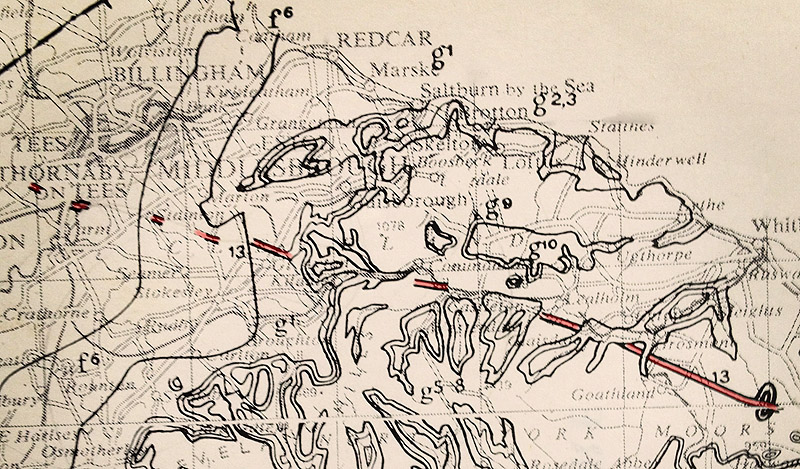
OS Map surveyed 1853

spa-wood-surveyed-1893

OS Map surveyed 1893. Ironstone was discovered in the Eston Hills in 1850. There are at least 10 ironstone mines operating within a three mile radius of Slapewath.

Many of the industrial remains of Spa Wood and the surrounding area are documented on the excellent Hidden Teesside Website

Articles on Chartism on Teesside from the wonderful People’s Republic of Teesside Blog

References

Augustus Bozzi Granville (1783-1872): London physician-accoucher and Italian patriot. Alex Sakula. Journal of the Royal Society of Medicine Vol.76 October 1983

The Spas of England and Principle Sea-Bathing Places. Vol. 1  A.B. Granville 1841

The History and Antiquities of Cleveland: Comprising the Wapentake of East and West Langbargh, North Riding, County York. John Walker Ord. Pub. 184

The Cleveland Dyke

The Cleveland Dyke is a band of igneous rock that was injected, whilst molten, into the local rocks during the Tertiary period of geological time (approx 60 million years ago). The dyke originated in a large magma chamber beneath the Island of Mull on the west coast of Scotland and has been estimated to have taken between 1-5 days to travel to North Yorkshire.

Image

Looking from Cliff Rigg Quarry to the Langbaurgh Ridge. The old quarry sites along the ridge can be seen between the trees. I have often wondered whether the people who lived in this area during prehistory used the Langbaurgh Ridge as a routeway from the River Tees to the moorlands. Bronze Age burials have been found in Ingleby Barwick close to the outcrop of the dyke. There are many prehistoric sites around the outcroppings on the North York Moors, particularly on Fylingdales Moor.

Image

The dyke is mainly buried beneath glacial deposits but  outcrops at a number of locations across Cleveland and the North York Moors. Where ever the dyke outcrops it has generally been quarried away. The rock, a basaltic andesite  but popularly known as whinstone, it is a very hard rock and was ideal for road building both as a hardcore and to make setts and blocks for surfacing.

Image

During the late 1800’s Leeds Corporation operated the quarries at Cliff Rigg just outside Great Ayton. The Middlesbrough to Whitby railway runs just beneath the quarry so it was possible to extract the stone and ship it by rail to Leeds.

Ironstone was also mined at Cliff Rigg and the surrounding area.

DSC_0684

Image