South Bank

I’ve been digging through some of my old images of the South Bank Coke Ovens. I took these around 2015. At the time it barely crossed my mind that within a decade the whole industry would be reduced to rubble.

The conservative government had an opportunity to save the industry and made the deliberate decision not to do so. The conservative mayor who vowed to bring steelmaking back to Teesside has also informed us that ‘a Tsunami’ of jobs are on the way.

Rise and Fall – Michael Guess

Saabat Gallery seeks to explore humanity’s relationship with the Industrial History of Teesside…. landscapes between the “rise and fall”, through the experiences and journey of a former steelwork engineer and photographer Michael Guess.

Azad Karim Mohammed

I went along to see this exhibition today and loved it. If you haven’t already been I’d recommend that you pop in and have a look.

Saabat Gallery

British Steel – South Teesside 1974

Mark Lawton very kindly sent me a scan of a book that he’d recently found. It’s a lovely snapshot from 1974 of the South Teesside Works when it employed 16,000 people.

You can download the whole book using the link at the bottom of the page

Printing with Iron – Cyanotypes for Sale

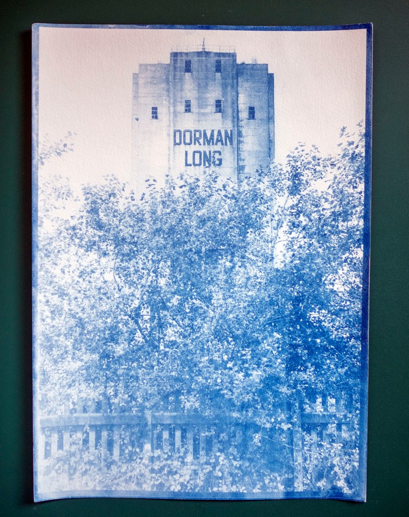
I’m selling some original Cyanotypes of the Dorman Long Tower. Cyanotype is a photographic printing process where the paper is coated with light sensitive iron salts and then exposed to UV light. Once exposed, the image is washed and then left to dry for 24 hours.

Each cyanotype is completely original, due to the vagaries of coating, exposure and washing, no two cyanotypes are the same. The image is made onto A4 330gsm acid-free paper. I may need to trim the edges slightly so the final image may be slightly smaller than A4.

Posting framed images would be rather costly so I’m selling them unframed. I’ve added a picture of a framed print below just to give you an idea of how they look. The prints are £15 plus £2 p&p each, with all profits going to the Trussell Trust. If you’d like to buy one send an email to smellofblackpath@gmail.com

The smell of t-shirts

I’m selling some lovely t-shirts. They were designed by Carl Mole and Oli Heffernan and feature the ‘Dorman Long Tower’ at South Bank, a landmark on the Teesside skyline. The tower was built during the 1950’s to store and supply coal to the South Bank coke ovens.

Designed by Carl Mole

Designed by Oli Heffernan

T-shirts available in 2 colours Grey/White

Sizes S, M, L & XL

Price £15 plus P&P

100% of profits will be donated to the Trussell Trust

email smellofblackpath@gmail.com stating design, colour & size

The Artists

Carl Mole Oli Heffernan

Black Path by Graham Vasey

Graham made the film during a recent walk that we took along the path. He filmed it using a 1930’s Ensign Auto Kinecam and expired Ilford FP4 Plus film which he processed himself.

The original soundtrack was created by Greg Marshall, the film was scanned by James Holcombe.

https://grahamvasey.wordpress.com/

https://vimeo.com/user10840987

23 – The Black Path

Read a history of The Black Path here https://teessidepsychogeography.wordpress.com/2020/05/05/the-black-path-8/

The Black Path

OLYMPUS DIGITAL CAMERA

The Black Path is a track that follows, for much of its route, the Middlesbrough to Redcar railway line. The final sections run across Warrenby Marsh and then along the South Gare to the river mouth. It also makes up the final stretch of the Teesdale Way, a long distance footpath that follows the River Tees from its source on Cross Fell to the sea. Although it is now seen as a leisure path it has a legacy that may predate the formation of England itself.

The modern path starts just behind the Navigation Pub in Middlesbrough and runs to the mouth of the River Tees.  The original path started at the ancient river crossing at Newport and followed the southern bank of the Tees to the river mouth at Tod Point. It is a route that has tracked a boundary between a number of ancient territories, the earliest of which may have been that of the Celtic Briton kingdom of Gododdin or Hen Ogledd, a name which means ‘the old north’.1039px-Northumbria.rise.600.700

In the late 5th century it followed the boundary between of the Anglian Kingdom of Deira to the south and the rival Kingdom of Bernicia to the north. These two territories were later combined to form the Kingdom of Northumbria.

England_878

Later, the Vikings founded the Kingdom of York, which stretched from the Humber to the Tees, so the paths route once again followed a significant north eastern boundary. The final ruler of the Kingdom of York was the wonderfully named Eric Bloodaxe, a Viking who could claim to have been the last true king of the North. The Kingdom of York gradually became the county of Yorkshire and the path marked the final land section of the counties north-eastern corner.

Middleton Warrior

Following the Norman Conquest in 1066, the north resisted the rule of the conqueror, prompting the new king and his Norman army to ride north to suppress the rebellion. Tradition has it that the English rebels had a camp of refuge on Coatham Marshes. If this is true, the path may well have been the route that the rebels used to escape from the Conqueror when he and his army rode into the district in an unsuccessful attempt to wipe out the rebels. This northern rebellion against king William would eventually lead to the Normans laying waste to much of the North during the infamous ‘Harrying of the North’.

Camp

From the Medieval period onwards the path was used by sailors and merchants to travel to and from ships at the ports of Coatham, Dabholm, Cargo Fleet and Newport, the path then became known as The Sailors Trod. This name appears in the early histories and on maps of the new town of Middlesbrough.

Sailors trod OS 1853 enlarged-2

During the industrial age, the railway was laid along the route of the track and the path was used by workers as a convenient route to the many industrial sites that had grown up along the river bank. This is when it became known as the Black Path, named for the industrial grime that lined the route.

As well of being used to move goods between the works along the river, the railway was utilised, along with boats and barges, to transport the materials being used to reclaim the land along the river bank, the reclamation of the land, coupled retaining walls being built along the river, resulted in the river bank moving further away from the route of the path.

a memory

I have walked the path many times and have recently noted the re-wilding of the area, I have seen foxes and hares along the path. The slag surrounding the path has decomposed to form lime-rich soils which support a variety plants that you cannot find anywhere else in our area, their seeds were carried through the narrow corridor by trains arriving with cargoes of limestone which was used as a flux in iron production.

Black Path Train 2

Today the path is only used for leisure purposes. I believe that, as it winds its way through the industrial hinterlands of Teesside, it is probably one of the most interesting and dramatic public footpaths in the country. If you have never walked the path I suggest you give it a go, it provides a wonderful insight into our industrial heritage and takes you to places that you cannot reach by any other means.

Coke oven triptych

Paintings –

The Black Path by Bob Mitchell. 2016

Coke Oven Triptych by Kirsty O’Brien. Painted as the Clay Lane Coke Ovens were closing in 2016

Maps

Northumbria Map Attribution – A compiled visualization from various public sources, CC BY-SA 3.0, link

England Map Attribution – link

Other Maps – Reproduced with the permission of the National Library of Scotland