Helmsley & Hawnby…not quite Damascus

Nikolaus Pevsner describes All Saints Church, Helmsley as ‘big and self confident, in the C13 style’.

It is always a good sign when the church entrance looks like this.

Stepping into the church is a joy, there are beautiful, bright, colourful murals everywhere.

The Victorian restorers of the church not only retained elements of the earlier church, they also added to them. The beakheads and outer order of the chancel arch are modern as are many other ‘romanesque’ features both within and on the exterior of the church, Rita Wood calls them ‘Heavy handed Victorian additions’, I quite like them.

The capital on the left side of the chancel arch has three heads carved on it, one creature emitting foliage and two small human heads, one wearing a pointy cap. The capital on the right side of the arch has a tiny head carved between the angle of the volutes.

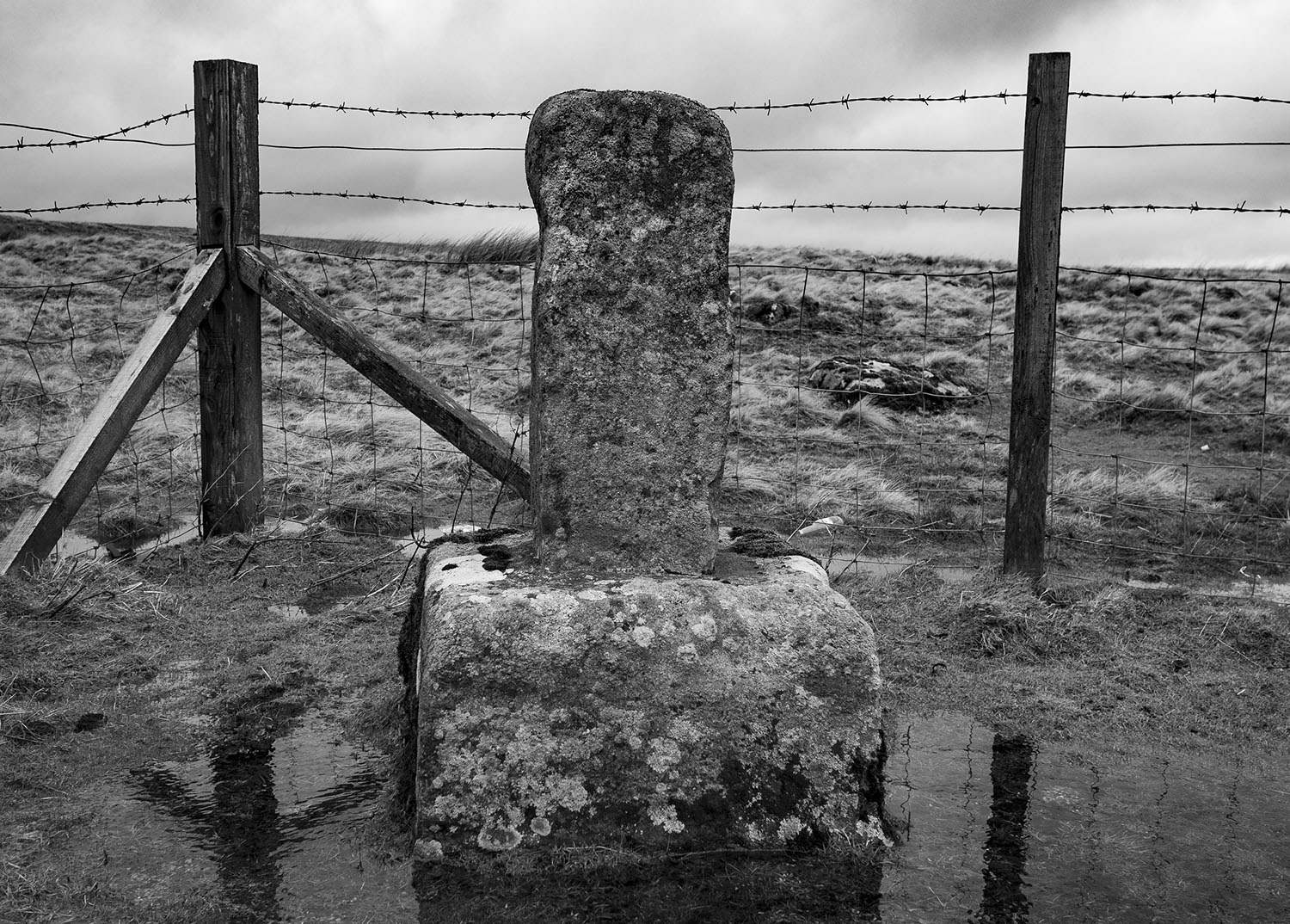
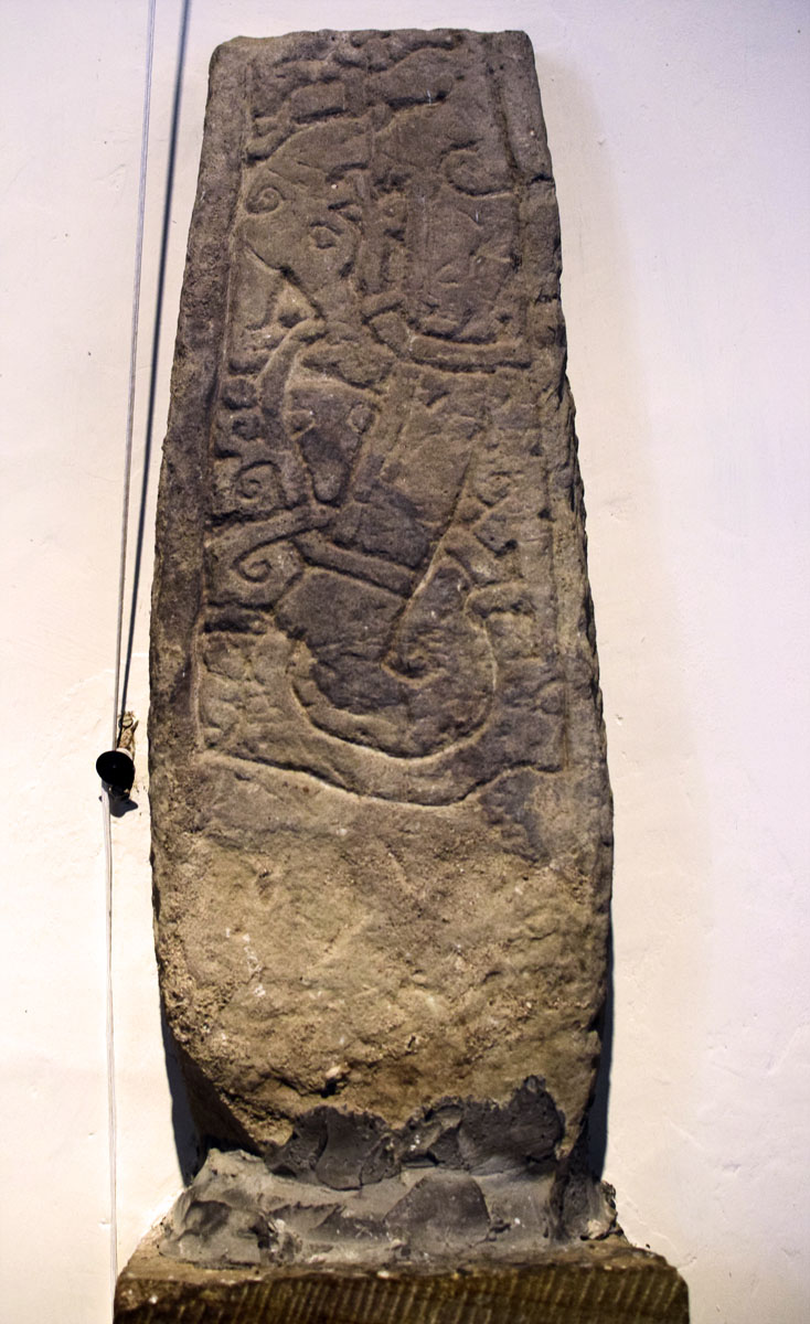
This 10th century Hogback is a bit knocked about, the motif on the top is quite a rare design to find on a Hogback, it is known as a Key Pattern.

There are two chapels within the church, the south chapel is dedicated to Columba and has an altar made of what looks like Swaledale Fossil Limestone and may have come from the quarries at Barton. The North Chapel is dedicated to Aelred and has an altar made with Frosterley Marble from Weardale.

This striking painting is in the north chapel, it’s by Gabriel Max and is called St. Veronica’s Handkerchief. When I first saw the painting, the image was of Christ with his eyes closed, when I looked again his eyes were open. I found this rather disturbing, I was raised in a strict catholic household but have been an atheist, with the odd lapse into heathendom, for the past 45yrs. Was this to be my moment of conversion? was the shepherd calling me back to the fold?…then I read the notice beside the painting … ‘was painted in the middle of the 19th century, it is a form of art with a little trick, where the eyes of christ can be seen either open or closed‘…I laughed, relieved but also feeling slightly unnerved by the experience.

On reflection, I quite like the painting, it was inspired by a miraculous handkerchief that contained a perfect image of the face of Christ. As usual with these sort of Medieval relics, there were three in existence, all claiming to be the original. I suppose most religions have to rely on some form of smoke and mirrors when it comes to dealing with the supernatural.

All Saints is a wonderful church and well worth a visit if you are in the area. The history of the district is written all over its walls often in bold bright mural form. Architecturally it has embraced and built upon its past and is currently undergoing further exterior renovations. The church is open for visitors from 9-5 daily.

Postscript

Driving home I remembered that in her book, Romanesque Yorkshire, Rita Wood compared the tiny carving of a man in a pointy cap to a carving in the church at Hawnby. Hawnby wasn’t too far from Helmsley so I decided to seek it out.

The Church at Hawnby, All Saints, can be found to the west of the village on the Kepwick road. The little church sits in an overgrown churchyard down by the River Rye, the setting is beautiful. The church is picturesque but architecturally fairly unremarkable, Pevsner describes it as ‘basically Norman‘. I found the carving located just inside the church door, it is lovely. Rita Wood thinks that it probably came from the chancel arch, who knows?

Sources

The Buildings of England. Yorkshire, The North Riding. Nikolaus Pevsner. Penguin Books. 1973

Romanesque Yorkshire. Rita Wood. Yorkshire Archaeological Society. Occasional Paper No.9. 2012

Yorkshire A Gazetteer of Anglo-Saxon & Viking Sites. Guy Points. Rihtspell Publishing. 2007

Wandering around Hexham Abbey

We took a trip up to Hexham, I spent half an hour wandering around the Abbey. As you walk into the Abbey you are faced with a Roman Tombstone, discovered in 1881, it is a memorial to Flavinus, a standard bearer. The carving depicts Flavinus riding over, what I presume is, a native Briton, the victors boot planted on his victims backside. The triumphs of past conquests are often displayed our churches, it is rare to see a memorial depicting our own islands conquest and defeat.

The original Saxon church was built using stone from nearby Roman sites. The church has been attacked many times during raids by the Vikings and later the Scots.

To the left of the High Altar is the Leschman Chantry Chapel, containing the tomb of Rowland Leschman, Prior of the Abbey from 1480 to 1491. The carvings on the tomb are an absolute joy.

The Smell of Water Part 3: Danby Rigg

Travelling stones – All Saints Old Church Skelton

..that of all the unfortunately plain – not to say ugly – structures which do duty for churches in Cleveland this is about the plainest and the most tasteless. One ancient buttress, of Early English character, remains on the north side of the chancel, and that is all which is left to testify to the former existence on this site of a really ecclesiastical building.

History of Cleveland Ancient & Modern Vol.1 Rev J. C. Atkinson. 1874

The lovely Norman font was brought from the ruined church of St Andrew at Upleatham. Rita Wood describes it as square with corner columns and central panels that have bold, well-carved geometric patterns. She tells us that there are similar fonts at Marske and Sneaton that are likely to have been carved by the same person.

There are a number of stone fragments inside the church including Upleatham’s Big Stone.

One of the stone fragments is the remains of a Hogback Grave that has probably been re-used as a building block. it is described as a child’s gable-end grave slab. It is classified as a Type E (dragonesque) Hogback, a type confined to the east coast of Yorkshire. It closely resembles two examples found at Lythe.

The Hogback stone has had a bit of a journey. It was found during an excavation at Upleatham old church, it was then moved into the new church in the village. When the new church was converted into a private home the stone was moved to Kirkleatham museum, where it is currently listed as being located.

Sources

History of Cleveland Ancient & Modern Vol.1 Rev. J.C. Atkinson. 1874

Romanesque Yorkshire. Rita Wood. 2012

Yorkshire – A Gazetteer of Anglo-Saxon & Viking Sites. Guy Points. 2007

The Corpus of Anglo-Saxon Stone Sculpture

The Black Path

OLYMPUS DIGITAL CAMERA

The Black Path is a track that follows, for much of its route, the Middlesbrough to Redcar railway line. The final sections run across Warrenby Marsh and then along the South Gare to the river mouth. It also makes up the final stretch of the Teesdale Way, a long distance footpath that follows the River Tees from its source on Cross Fell to the sea. Although it is now seen as a leisure path it has a legacy that may predate the formation of England itself.

The modern path starts just behind the Navigation Pub in Middlesbrough and runs to the mouth of the River Tees.  The original path started at the ancient river crossing at Newport and followed the southern bank of the Tees to the river mouth at Tod Point. It is a route that has tracked a boundary between a number of ancient territories, the earliest of which may have been that of the Celtic Briton kingdom of Gododdin or Hen Ogledd, a name which means ‘the old north’.1039px-Northumbria.rise.600.700

In the late 5th century it followed the boundary between of the Anglian Kingdom of Deira to the south and the rival Kingdom of Bernicia to the north. These two territories were later combined to form the Kingdom of Northumbria.

England_878

Later, the Vikings founded the Kingdom of York, which stretched from the Humber to the Tees, so the paths route once again followed a significant north eastern boundary. The final ruler of the Kingdom of York was the wonderfully named Eric Bloodaxe, a Viking who could claim to have been the last true king of the North. The Kingdom of York gradually became the county of Yorkshire and the path marked the final land section of the counties north-eastern corner.

Middleton Warrior

Following the Norman Conquest in 1066, the north resisted the rule of the conqueror, prompting the new king and his Norman army to ride north to suppress the rebellion. Tradition has it that the English rebels had a camp of refuge on Coatham Marshes. If this is true, the path may well have been the route that the rebels used to escape from the Conqueror when he and his army rode into the district in an unsuccessful attempt to wipe out the rebels. This northern rebellion against king William would eventually lead to the Normans laying waste to much of the North during the infamous ‘Harrying of the North’.

Camp

From the Medieval period onwards the path was used by sailors and merchants to travel to and from ships at the ports of Coatham, Dabholm, Cargo Fleet and Newport, the path then became known as The Sailors Trod. This name appears in the early histories and on maps of the new town of Middlesbrough.

Sailors trod OS 1853 enlarged-2

During the industrial age, the railway was laid along the route of the track and the path was used by workers as a convenient route to the many industrial sites that had grown up along the river bank. This is when it became known as the Black Path, named for the industrial grime that lined the route.

As well of being used to move goods between the works along the river, the railway was utilised, along with boats and barges, to transport the materials being used to reclaim the land along the river bank, the reclamation of the land, coupled retaining walls being built along the river, resulted in the river bank moving further away from the route of the path.

a memory

I have walked the path many times and have recently noted the re-wilding of the area, I have seen foxes and hares along the path. The slag surrounding the path has decomposed to form lime-rich soils which support a variety plants that you cannot find anywhere else in our area, their seeds were carried through the narrow corridor by trains arriving with cargoes of limestone which was used as a flux in iron production.

Black Path Train 2

Today the path is only used for leisure purposes. I believe that, as it winds its way through the industrial hinterlands of Teesside, it is probably one of the most interesting and dramatic public footpaths in the country. If you have never walked the path I suggest you give it a go, it provides a wonderful insight into our industrial heritage and takes you to places that you cannot reach by any other means.

Coke oven triptych

Paintings –

The Black Path by Bob Mitchell. 2016

Coke Oven Triptych by Kirsty O’Brien. Painted as the Clay Lane Coke Ovens were closing in 2016

Maps

Northumbria Map Attribution – A compiled visualization from various public sources, CC BY-SA 3.0, link

England Map Attribution – link

Other Maps – Reproduced with the permission of the National Library of Scotland

Rey Cross ii

OE stan ‘stone, stones’ is a very common pl. el. It is used alone as a pl. n. in STAINES, STEANE, STONE, where a Roman milestone or some prominant stone of another kindmay be referred to.

The Concise Oxford Dictionary of English Place Names. Eilert Ekwall. 1959

I recently took a trip over the Pennines to Cumbria. On the way home I stopped on Stainmore to have a look at Rey’s Cross. The Cross is located in a lay-by beside the A66. The A66 crosses the Pennines through the Stainmore Gap, a Pennine pass that was created by the flow of ice sheets during past glacial periods.

Historically, This part of Stainmore has always been important. The moor is rich in late Prehistoric remains. It was also the site of a large Roman marching camp, within the ruins of the camp is a wrecked prehistoric stone circle. Legend has it that the stone cross was raised as a memorial to Eric Bloodaxe, the last king of York, who was slain on the moor in 954.

Eric_Bloodaxe_coin_b

The cross, situated near the highest point of Stainmore, is close to an ancient county boundary, is a weathered shaft set into a substantial stone base and is thought to date to the early anglo saxon period. The name`Rey’ is thought to have been derived from the Old Norse element `hreyrr’ which can be taken to mean a heap of stones forming a boundary.

OLYMPUS DIGITAL CAMERA

One of the earliest references to the stone is from The Chronicle of Lanercost where it is call ” Rer Cros in Staynmor ” The chronicler states that it was set up as a boundary marker. The boundary was between the Westmoringas and the Northumbrians, the Glasgow diocesan border, before that it marked the border between the Cumbrians and the Northumbrians.

map

The antiquarian William Camden tells us ” This stone was set up as a boundary between England and Scotland, when William (the Conqueror) first gave Cumberland to the Scots.”  Camden was incorrect, at the time of the Norman conquest much of Cumberland was already under Scot’s rule. The historic county of Cumberland was not established until 1177, however the stone could still have marked the boundary of the territory.

The A99 was widened in the early 1990’s so in 1990 the stone was moved from the south side of the road to its present site on the north side. An archaeological survey and excavation was undertaken as part of a wider archaeological project, sadly no burial was found beneath or around the stone.

OLYMPUS DIGITAL CAMERA

What fascinates me about this stone is that it marks a place that has been significant to the people of our islands for thousands of years. The people of the Neolithic period used this as route way between the east and west coasts. Later, the people bronze age erected a stone circle close to the site. Later still, the Romans heavily fortified road to guard the legions marching between Catterick and Penrith and it has remained the primary northern trans-pennine link ever since.  A hundred or so metres west of the stone is the modern east/west boundary between Cumbria and Durham and the route was also once the medieval border between Scotland and England. East meets west, north meets south all within sight of the weather-beaten old stone.

Into Eden – Dacre

Skirsgill

Heading west from Great Salkeld towartds Dacre, I called in on an old friend, the Skirsgill standing stone. Tucked away on an industrial estate, the huge stone is almost lost in foliage, not a bad thing perhaps. I took this picture of the stone in 2004

Plaque

St Andrew’s Church, Dacre. A Norman church built on a pre-conquest Christian site.

Dacre

A beautiful 9th century cross shaft.

Cross Shaft

Description

The slab-like shaft is complete, as is clear from the presence of both upper and lower border mouldings to the panels on sides D and E. The edge of the head on face A and all faces of the shaft were bordered laterally by a roll moulding.

A (broad): At the top and bottom of the shaft is a border formed by a single incised line; two wavering parallel lines divide the two panels on the shaft. On the head are remains of interlace of unidentifiable type. At the top of the shaft is a backward-turning contoured quadruped with a small scooped ear; the ground around the animal has not been cut back. Below are two human figures, the larger to the right, whose hands are joined over a rectangular object with two pellet-like legs. Between their heads is a cluster of three pellets. The ground to the right of the figures has not been cleared completely but sprouts curling or circular branches.

Below the left-hand figure is an uncarved area shaped like a boat, which partially separates this scene from the one below which contains a horned quadruped on whose back is a crouching wolf/dog with curling tail. The ground in front of the horned animal and between its legs has not been cut back.

Below the incised border the lower panel contains a Fall scene. The female figure to the left is clothed in a short kirtle and reaches to pluck a fruit pellet from the tree. The right-hand figure, who is not clearly clothed, grasps a branch. A snake coils to the left of the tree. The ground around this scene has not been completely cleared.

Source – The Corpus of Anglo-Saxon Stone Sculpture 


The Dacre Bears

The bears are a genuine mystery, no one really knows their origin or meaning. This is from the St Andrew’s church website

The Dacre Bears are a special feature at St. Andrew’s. There are four stone statues located within the churchyard. A recently expressed archaeological opinion is that they are pre-Saxon and may originally have marked the boundaries of some pagan sacred site, however, the origin of the Bears is unknown and has been a puzzle for centuries.


Eric Bloodaxe

Odin: What have I dreamed? 
The day awoke I 
Valhall to put in order, 
Ripe for receiving 
Warriors famous. 
Wake I the champions, 
Bid them uprise, 
Benches to cover, 
Tables to scour. 
Wine of the Valkyries 
Bear to a monarch. 
Hither from wide world 
Warriors are coming, 
Gladdening my heart. 
What thunder rumbles, 
Shaking earth’s basis, 
As millstones grind? 

Bragi: Bench-breaking burdens, 
Baldur is coming 
To Odin’s hall. 

Odin: Now thou speakst falsely, 
Bragi, right noble, 
Grown old and witless; 
Eric the Thunderer 
He comes a guesting 
Here in this hall. 
Sigmund, Sinfjotli,
Rise up, right speedy, 
Meet ye the wrathful. 
Bid him right welcome, 
If it be Eric 
Who now is coming. 

Sigmund: Why heave you Bloodaxe 
Higher than all else? 

Odin: Why? mighty kingdoms 
Harried and havocked 
Hath he with blood-brand. 

Sigmund: Why forbid victory 
To him, the shrewdest? 

Odin: Well, not to know all, 
Grey wolf devours 
All of the world sheep. 

Sigmund: Hail to thee, Eric! 
Welcome to Valhall! 
Go to the high seat; 
Yet will I ply thee 
With many queries, 
Whether there follow 
Many more warriors 
From field of battle.  

Eric: I am a high king, 
Known is my title, 
Height am I, Eric, 
I am the sixth. 

Eric Bloodaxe

Sinnington

I arrived at the church just as the warden was leaving she told me that she had just opened up the church and showed me the key, it was about a foot long with a shaft as thick as my thumb.

I’m going to have a little rant now.

The churches I have visited over the past few days have all been open and welcoming but many that I visit are not, they are locked and covered in signs warning thieves to beware. I am aware that theft from churches is a real problem in some areas, I am also aware that church attendance is dwindling rapidly.

Churches are primarily places of worship, I do not subscribe to any religion but I do get a sense of tranquil otherworldliness when I visit a beautiful old church. These institutions are also custodians of our history and culture. Their walls reflect the history of our islands and our communities, to deny people access to these spaces can only perpetuate the decline of these institutions. I’m not sure what the solution to this problem is but I know that locking a church up for six days a week does not help anyone and can only foster a feeling of exclusion in the wider population.

The church and the village pub are both in decline in many areas, William Blake offered a solution in his poem The Little Vagabond.

Dear Mother, dear Mother, the Church is cold,
But the Ale-house is healthy & pleasant & warm;
Besides I can tell where I am use’d well,
Such usage in heaven will never do well.
*
 But if at the Church they would give us some Ale.
And a pleasant fire, our souls to regale;
We’d sing and we’d pray, all the live-long day;
Nor ever once wish from the Church to stray,
*
 Then the Parson might preach & drink & sing.
And we’d be as happy as birds in the spring:
And modest dame Lurch, who is always at Church,
Would not have bandy children nor fasting nor birch.
*
And God like a father rejoicing to see,
His children as pleasant and happy as he:
Would have no more quarrel with the Devil or the Barrel
But kiss him & give him both drink and apparel.
*
There are lots of carved stones both inside and outside of this beautiful church, here are a few.

Sinnington

This carving has been interpreted as a Jelling bound dragon.

Sinnington vi

This small inconsequential stone, carved with a crude cross, measures about 10cm square. It is known as a consecration cross and indicates a place where the wall of the church was touched with holy oil during the consecration of the church. There are a number of other small crude crosses carved on the external walls particularly around the original entrance, which is now blocked and filled with a number of carved stones.

Sinnington i


A lovely pair cross heads built into the exterior walls