
Drawing the Cupola and the end of a day’s melt (Cochrane’s) – T. S. Hutton

The Black Path is a track that follows, for much of its route, the Middlesbrough to Redcar railway line. The final sections run across Warrenby Marsh and then along the South Gare to the river mouth. It also makes up the final stretch of the Teesdale Way, a long distance footpath that follows the River Tees from its source on Cross Fell to the sea. Although it is now seen as a leisure path it has a legacy that may predate the formation of England itself.
The modern path starts just behind the Navigation Pub in Middlesbrough and runs to the mouth of the River Tees. The original path started at the ancient river crossing at Newport and followed the southern bank of the Tees to the river mouth at Tod Point. It is a route that has tracked a boundary between a number of ancient territories, the earliest of which may have been that of the Celtic Briton kingdom of Gododdin or Hen Ogledd, a name which means ‘the old north’.
In the late 5th century it followed the boundary between of the Anglian Kingdom of Deira to the south and the rival Kingdom of Bernicia to the north. These two territories were later combined to form the Kingdom of Northumbria.

Later, the Vikings founded the Kingdom of York, which stretched from the Humber to the Tees, so the paths route once again followed a significant north eastern boundary. The final ruler of the Kingdom of York was the wonderfully named Eric Bloodaxe, a Viking who could claim to have been the last true king of the North. The Kingdom of York gradually became the county of Yorkshire and the path marked the final land section of the counties north-eastern corner.

Following the Norman Conquest in 1066, the north resisted the rule of the conqueror, prompting the new king and his Norman army to ride north to suppress the rebellion. Tradition has it that the English rebels had a camp of refuge on Coatham Marshes. If this is true, the path may well have been the route that the rebels used to escape from the Conqueror when he and his army rode into the district in an unsuccessful attempt to wipe out the rebels. This northern rebellion against king William would eventually lead to the Normans laying waste to much of the North during the infamous ‘Harrying of the North’.

From the Medieval period onwards the path was used by sailors and merchants to travel to and from ships at the ports of Coatham, Dabholm, Cargo Fleet and Newport, the path then became known as The Sailors Trod. This name appears in the early histories and on maps of the new town of Middlesbrough.
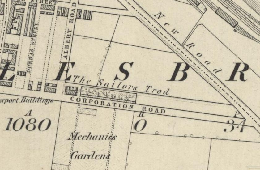
During the industrial age, the railway was laid along the route of the track and the path was used by workers as a convenient route to the many industrial sites that had grown up along the river bank. This is when it became known as the Black Path, named for the industrial grime that lined the route.
As well of being used to move goods between the works along the river, the railway was utilised, along with boats and barges, to transport the materials being used to reclaim the land along the river bank, the reclamation of the land, coupled retaining walls being built along the river, resulted in the river bank moving further away from the route of the path.

I have walked the path many times and have recently noted the re-wilding of the area, I have seen foxes and hares along the path. The slag surrounding the path has decomposed to form lime-rich soils which support a variety plants that you cannot find anywhere else in our area, their seeds were carried through the narrow corridor by trains arriving with cargoes of limestone which was used as a flux in iron production.

Today the path is only used for leisure purposes. I believe that, as it winds its way through the industrial hinterlands of Teesside, it is probably one of the most interesting and dramatic public footpaths in the country. If you have never walked the path I suggest you give it a go, it provides a wonderful insight into our industrial heritage and takes you to places that you cannot reach by any other means.

Paintings –
The Black Path by Bob Mitchell. 2016
Coke Oven Triptych by Kirsty O’Brien. Painted as the Clay Lane Coke Ovens were closing in 2016
Maps
Northumbria Map Attribution – A compiled visualization from various public sources, CC BY-SA 3.0, link
England Map Attribution – link
Other Maps – Reproduced with the permission of the National Library of Scotland


High and dry in twenty ten. The options roll out but none appeal. he needs his son to feel alive
Seven Pounds of Hope and Five Ounces of Fear by Ray Lonsdale

They may be men of steel but they are men with loves, responsibilities and nowhere to go. They are men who make things…things that have built countries.
Wipe Clean with a Soft Cloth by Ray Lonsdale

No more smoke, dirt, noise or ugly views and peaceful in the job centre queues.
An Arm Full of Sharp Things by Ray Lonsdale

(c) mima Middlesbrough Institute of Modern Art; Supplied by The Public Catalogue Foundation


 Iron and steel making ended at Cargo Fleet in 1973 when the British Steel Corporation moved steel production to Lackenby resulting in two thousand workers losing their jobs. Parts of the works remained open until the gates were finally closed in the 1980’s.
Skinningrove beam spotted in the Bottle Cap Brewery, Aberdeen

Cargo Fleet beam spotted on an oil production platform in the North sea


The (Middlesbrough) Corporationreceived the Royal Assent on the 7th July 1856 to an Improvement Act which gave power to divide the town into wards, to light the district, enlarge the market and to let off the market tolls, to appoint an Inspector of Weights and Measures, to establish a public wharf and ferry, to adopt bye-laws for the layout of streets, and to divert a sailors’ trod between Middlesbrough and Cargo Fleet, and gave power to purchase the gas works.
It was in 1855 that the Middlesbrough Owners tried to stop the path to Cargo Fleet, and on 10th April 1855 the Corporation demanded the removal of the obstructions. In February 1856 the Owners agreed to pay all costs for its diversion. It was not until 9th April 1861 that the riverside sailors’ trod, which ran through a brickyard on the Pennyman Marshes, was diverted along a route parallel with the railway. This path became known as the Black Path.The History Of Middlesbrough.
William Lillie.
1968

A number of early scenes in Lindsay Anderson’s 1973 film were filmed in and around Middlesbrough, particularly the South Bank area.

Malcolm McDowell’s character travelling salesman, Mick Travis, drives towards South Bank with the Clay Lane blast furnaces in the distance.

Here Mick drives into Cochranes works at Cargo Fleet

Mick driving along the A19. Prior to the widening of the road, the Cameron’s Brewery ‘You are now entering Strongarm Country’ sign was a very recognisable landmark on the section of the road between Middlesbrough and Billingham

