Escaping the mad parade

Walking from Farndale up towards Rudland Rigg, we followed the track up the side of Monket Bank. The track climbs up through the old jet workings and quarries along the moor edge.

In the 14th century this route was known as Monckgate and linked Bransdale with Farndale. The track was used as a Church or Corpse Road with coffins being carried over the rigg to Cockan Kirk in Bransdale.

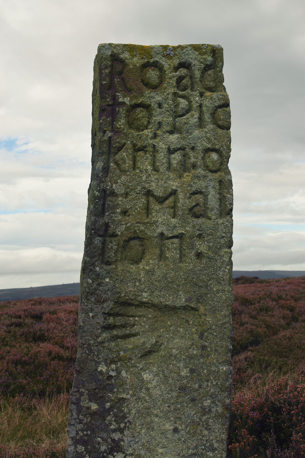
The road across the rigg is now known as Westside Road, in the past, it was known as Waingate, running from Kirkbymoorside Market Place in the south to Battersby Bank in the north.

We cut out across the moor towards Ousegill Head and the Three Howes. Flint tools had been found by the gamekeepers for a number of years so in September 1973 Raymond Hayes and others excavated the area. His small excavation yielded over 800 flints from an area of 3.50 x 3.0m. The site was interpreted as ‘A temporary camping site in a forest clearing, probably being occupied by hunters following red deer or other game.’

Whilst at the Three Howes we saw a Red Kite being harassed by an anxious Curlew. Once the Kite had rid itself of its tormentor it flew directly over us, a joyful moment, this was my first sighting of a Kite on the moors.

We walked back across the old peat workings and rejoined the track, moving on to the waymarker at Cockam Cross and then onto our final goal, the Cammon Stone.

The Cammon Stone is a prehistoric standing stone that sits just beside the main track. The stone is about a metre and a half tall and leans towards the west. I have been visiting this stone on and off for at least two decades, my perception is that the lean of the stone has increased over the years but I may be wrong, I hope I am. The southern views from the stone look down along Bransdale, the axis of the stone is also aligned in this direction, which is probably no coincidence.

There are a number of faded letters carved onto the western face of the stone, in the past, antiquarians had speculated as to whether these letters were Phoenician in origin. They are actually Hebrew and spell out the word halleluiah. They are thought to be the work of the Reverend W Strickland, Vicar of Ingleby. Strickland is thought to be responsible for carving a number of inscriptions in this area.

There is a second stone, a large flat slab. No one knows whether this slab ever stood upright. There is no obvious weathering patterns to indicate that it might have been upstanding but I guess that question could only ever be answered by an archaeological investigation.

We picked our way along a track that ran from the moortop into Farndale and joined the daleside road at Spout House. If you are a fan of stone walls and troughs, you will love this road, it has massive walls with stone-lined gutters and numerous multiple carved stone troughs. The stonemasons and wallers were once kept busy in this area.

Also on this road is the Duffin Stone, a massive boulder that has tumbled down from the escarpment side and is embedded into the verge of the narrow lane. The stone bears the scars of contact with many vehicles.

Etymology

Waingate – OE Waen Way – Waggon Road

Monket – The ‘Mun(e)k(e)’ spellings suggest ‘monks’, but in the absence of monastic associations one might suspect an earlier ‘Mened-cet’ (Welsh Mynydd-coed) – ‘forest hill’. Here one might compare ‘Monket House’ in north-east Yorkshire.

Cammon Stone – Cam Maen – Bank Stone.

Rudland – OE hrycg ON hyrggr ‘ridge’.

Sources

Old Roads & Pannierways in North East Yorkshire. R. H. Hayes.1988. The North York Moors National Park.

Yorkshire Archaeological Journal. Vol.67. 1995. The Yorkshire Archaeological Society.

The Consise Oxford Dictionary of English Place-Names. Eilert Ekwall. 1974. Oxford.

A STONE CIRCLE, HOB’S HEAP & THE COAL MINES OF HARLAND MOOR PT. 3

Hob-Trush Hob, wheer is thoo?

I’s tryin’ on my left-foot shoe,

An’ I’ll be wi’ thee–noo!

After a little bit of  to-ing and fro-ing Chris and I arrived at Obtrusch Rook. The cairn is not not difficult to find, it’s marked clearly on the OS map, visible on the ground and set apart from the bell pits. It isn’t located on the highest part of the moor but you can see that the site was chosen to maximise the views across Farndale and Blakey Rigg to the north and east with the Vale of Pickering opening out to the south. The cooling towers and chimneys of the power stations at Drax and Ferrybridge are visible on the far horizon, a distance of about 60 miles.

ob


The ruined cairn with Blakey Rigg in the distance. A Sonotaphonomist provides scale.

Frank Elgee discussed the origins of the name Obtrusch Rook in his wonderful book, Early Man in North East Yorkshire (1930)

Rook, from the old Norse hraukr, means a pile or heap of anything, more particularly of stones or turves, though occasionally, as in the present instance, it is bestowed on barrows. Obtrush or Hobtrush was the name of a local supernatural being, akin to an elf or hobgoblin, of whom many quaint stories are current, and who haunted ancient sites. Besides Hobtrush Rook, the goblin’s heap, we also have Hob-on-the -Hill, a barrow on Guisbrough Moor, Hob Hill, an Anglian burial ground near Saltburn; and Hob Hole near a prehistoric settlement in Baysdale.

rudland-map

The cairn is fairly ruined and shows very little of the features recorded during its 1836 excavation by the  pioneering Yorkshire Geologist, John Phillips. His account is given below.

obtrusch

Near the line of the road which has been mentioned, a conspicuous object for many miles round, was the large conical heap of stones called Obtrush Roque. In the dales of this part of Yorkshire we might expect to find, if anywhere, traces of the old superstitions of the Northmen, as well as their independence and hospitality, and we do find that Obtrush Roque was haunted by the goblin. But ‘Hob’ was also a familiar and troublesome visitor of one of the farmers, and caused him so much vexation and petty loss, that he resolved to quit his house in Farndale and seek some other home. Very early in the morning, as he was trudging on his way, with all his household goods and gods in a cart, he was accosted in good Yorkshire by a restless neighbour, with “I see you’re flitting.” The reply came from Hob out of the churn – “Ay, we’re flutting.” Upon which the farmer, concluding that change of air would not rid him of the daemon, turned his horse’s head homeward. This story is in substance the same as that narrated on the Scottish Border, and in Scandinavia; and may serve to show for how long a period and with what conformity, even to the play on the vowel, some traditions may be preserved in secluded districts.

This goblin-haunted mound was elevated several feet above the moorland, and was covered with heath. Under this was a great collection of sandstones loosely thrown together, which had been gathered from the neighbouring surface. On removing them, a circle of broader and larger stones appeared set on edge, in number 25, or, allowing for a vacant place, 26. Within this was another circle, composed of smaller stones set edgeways, in number 25 or 26 ; and the centre of the inner space was occupied by a rectangular kist, composed of four flagstones set edgeways. The sides of this cyst pointed east and west and north and south ; the greatest length being from east to west. On arriving at this fortunate result of our labour, our expectations were a little raised as to what might follow. But within the kist were no urns, no bones, no treasures of any kind, except a tail-feather from some farmyard chanticleer. The countrymen said this place of ancient burial had been opened many years ago, and that then gold was found in it. It seemed to us that it must have been recently visited by a fox.

Considering the position of the kist, set with careful attention to the cardinal points; the two circles of stone; the number of these stones, which if completed appeared to be 26; it seemed not unreasonable conjecture, that the construction contained traces of astronomical knowledge, of the solar year, and weekly periods. I dare not confidently affirm this. Was this a relique of an early British chief, or of a later Scandinavian warrior ? for such circles have been raised in Scandinavia and the Orkney Islands by the Northmen, and this is a district which the Northmen colonized. A similar circle of stones occurs at Cloughton near Scarborough.

The Rivers, Mountains & Sea Coast. London.1853

A Stone Circle, Hob’s Heap & the Coal Mines of Harland Moor Pt 2.

Chris and I left the stone circle on Harland Moor and headed north across the open moorland onto Rudland Rigg. We’d noticed that the ground was disturbed on the lower moor with numerous small pits but as we moved up onto the higher moor we began to notice large mounds running across the moor.

The mounds are the remains of the Rudland Colliery. Coal mining was carried out across the moors  for more than three centuries. There were small collieries exploiting thin seams extending from Crathorne in the Tees valley to Whitby on the coast. The moorland coal is found in thin seams between five and nine inches thick in the Middle Jurassic formations. The coal is poor in quality but is suitable for burning in limekilns and for domestic use. The production of lime was a seasonal activity so the mining was done by small groups of men who also had small holdings or worked in other industries during the winter months.

Cobble Hall Limekilns

Cobble Hall Limekilns

The coal was initially mined by digging small pits and extracting the deposits that were close to the surface, as can be seen in the area around the stone circle. Once shallower deposits had been exhausted, deeper shafts giving access to underground interconnecting galleries were sunk. With no means of ventilation and the difficulty of moving materials through the galleries, a series of shafts were sunk with a pillar of no less that one yard left between shafts to support the roof. These shafts are commonly known as Bell Pits.

bell

The coal was removed from the pit by a hand operated windlass or a horse powered winch known as a Gin.

The Rudland colliery is comprised of 270 pits running in lines across the moor, other collieries in the immediate area were the Upper Rudland (140 pits), Harland Head (60 pits), and Swinakel (19 pits).

Unlike the other extractive industries of the moors such as Jet, ironstone mining  and alum production, coal mining on the moors was only of local importance. It was however an important part of the local economy. The Lime was needed to improve the fertility of the soils especially the acidic soils of the northern dales.

rudland-rigg-colliery

Source

The North York Moors Coalfield M.C. Gill. 2010

A Stone Circle, Hob’s Heap & the Coal Mines of Harland Moor Pt 1.

Yesterday I realised that I’d recently written a blog post about manhole covers..manhole covers! I’ve had a fairly odd few weeks which have left me unable to venture to far from home, I needed to clear my head and for me the best way to do that is a mooch across an empty moor. I sent my good friend and co-conspirator Chris Whitehead a message, an hour and a half later we met in the car park of the Lion Inn on Blakey Ridge, our destination Harland Moor.

It’s a lovely drive down to Harland Moor we stopped briefly on Blakey Rigg to admire the beautifully carved handstone.

hand-stone

After dodging suicidal pheasants we arrived at the circle which is marked on the OS map as a cairn. The circle was discovered by W R Crosland in 1930 and was described as an embanked circle 70ft in diameter with upright stones set at intervals.  

It had been at least a decade since I last visited the circle and remembered it as a rather ruinous place. I was surprised to find it quite recognisable, a slightly raised bank set with stones. The circle is bisected by a hollow way with dense heather and bracken in the northern and eastern quadrant, which made spotting the stones a little difficult.

harland-circle

harland-circle1

Britain’s foremost expert on stone circles, Aubrey Burl, gives the circle a classification of 3 (Ruined but recognisable), I wouldn’t argue with that. A few metres to the west of the circle there are a number of stones that may be the remains of prehistoric walling but are so ruined that it is hard to tell. Interestingly, the three stones in the picture below are aligned 130 – 300 degrees which roughly aligns to the winter solstice sunrise and summer solstice sunset for 2000BCE.

harland-circle2

The main viewshed from the circle is to the south and west across the green tabular hills dipping down to the fertile Vale of Pickering below. The views to the north and east are of the golden brown high moors intercut with fertile green dales.

We decided to leave the circle, fortified by ripe, fat, sweet, juicy bilberries we headed north across the moor.

Sources

A History of Helmsley & Rievaulx & District. J. McDonnell 1963

Prehistoric & Roman Archaeology of North East Yorkshire. D A Spratt 1993

The Stone Circles of Britain Ireland and Brittany (Revised Edition). A Burl 2000