A Stone Circle, Hob’s Heap & the Coal Mines of Harland Moor Pt 2.

Chris and I left the stone circle on Harland Moor and headed north across the open moorland onto Rudland Rigg. We’d noticed that the ground was disturbed on the lower moor with numerous small pits but as we moved up onto the higher moor we began to notice large mounds running across the moor.

The mounds are the remains of the Rudland Colliery. Coal mining was carried out across the moors  for more than three centuries. There were small collieries exploiting thin seams extending from Crathorne in the Tees valley to Whitby on the coast. The moorland coal is found in thin seams between five and nine inches thick in the Middle Jurassic formations. The coal is poor in quality but is suitable for burning in limekilns and for domestic use. The production of lime was a seasonal activity so the mining was done by small groups of men who also had small holdings or worked in other industries during the winter months.

Cobble Hall Limekilns

Cobble Hall Limekilns

The coal was initially mined by digging small pits and extracting the deposits that were close to the surface, as can be seen in the area around the stone circle. Once shallower deposits had been exhausted, deeper shafts giving access to underground interconnecting galleries were sunk. With no means of ventilation and the difficulty of moving materials through the galleries, a series of shafts were sunk with a pillar of no less that one yard left between shafts to support the roof. These shafts are commonly known as Bell Pits.

bell

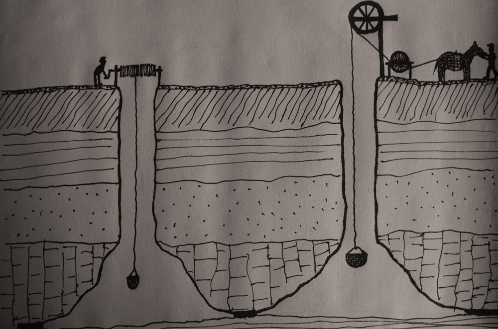
The coal was removed from the pit by a hand operated windlass or a horse powered winch known as a Gin.

The Rudland colliery is comprised of 270 pits running in lines across the moor, other collieries in the immediate area were the Upper Rudland (140 pits), Harland Head (60 pits), and Swinakel (19 pits).

Unlike the other extractive industries of the moors such as Jet, ironstone mining  and alum production, coal mining on the moors was only of local importance. It was however an important part of the local economy. The Lime was needed to improve the fertility of the soils especially the acidic soils of the northern dales.

rudland-rigg-colliery

Source

The North York Moors Coalfield M.C. Gill. 2010

A Stone Circle, Hob’s Heap & the Coal Mines of Harland Moor Pt 1.

Yesterday I realised that I’d recently written a blog post about manhole covers..manhole covers! I’ve had a fairly odd few weeks which have left me unable to venture to far from home, I needed to clear my head and for me the best way to do that is a mooch across an empty moor. I sent my good friend and co-conspirator Chris Whitehead a message, an hour and a half later we met in the car park of the Lion Inn on Blakey Ridge, our destination Harland Moor.

It’s a lovely drive down to Harland Moor we stopped briefly on Blakey Rigg to admire the beautifully carved handstone.

hand-stone

After dodging suicidal pheasants we arrived at the circle which is marked on the OS map as a cairn. The circle was discovered by W R Crosland in 1930 and was described as an embanked circle 70ft in diameter with upright stones set at intervals.  

It had been at least a decade since I last visited the circle and remembered it as a rather ruinous place. I was surprised to find it quite recognisable, a slightly raised bank set with stones. The circle is bisected by a hollow way with dense heather and bracken in the northern and eastern quadrant, which made spotting the stones a little difficult.

harland-circle

harland-circle1

Britain’s foremost expert on stone circles, Aubrey Burl, gives the circle a classification of 3 (Ruined but recognisable), I wouldn’t argue with that. A few metres to the west of the circle there are a number of stones that may be the remains of prehistoric walling but are so ruined that it is hard to tell. Interestingly, the three stones in the picture below are aligned 130 – 300 degrees which roughly aligns to the winter solstice sunrise and summer solstice sunset for 2000BCE.

harland-circle2

The main viewshed from the circle is to the south and west across the green tabular hills dipping down to the fertile Vale of Pickering below. The views to the north and east are of the golden brown high moors intercut with fertile green dales.

We decided to leave the circle, fortified by ripe, fat, sweet, juicy bilberries we headed north across the moor.

Sources

A History of Helmsley & Rievaulx & District. J. McDonnell 1963

Prehistoric & Roman Archaeology of North East Yorkshire. D A Spratt 1993

The Stone Circles of Britain Ireland and Brittany (Revised Edition). A Burl 2000