A few photos from about 20 years ago. They were taken in Cumbria, Derbyshire and Dumfries & Galloway.
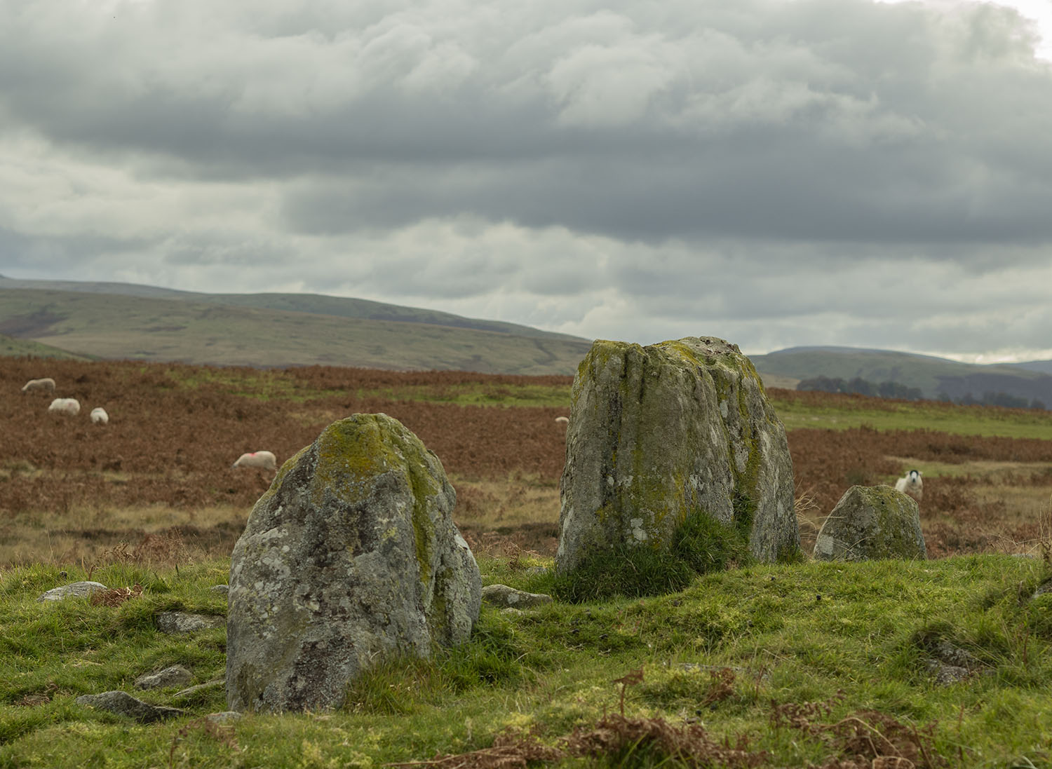
Stone Row


An exhibition

The Old Stones of the North Exhibition
Circumstances have prevented me from visiting our joint exhibition, so this week we took a trip over to Grasmere to have a look. I was impressed with the way that the Heaton Cooper Studio has presented our work. The exhibition runs until the 29th May.


Aubrey Burl
Last week I learned that Harry Aubrey Woodruff Burl had passed away at the age of 93.

Sometime in the mid 1980’s I discovered a book in a second hand bookshop called The Stone Circles of the British Isles by Aubrey Burl. I bought it, read it and re-read it, it changed my world.

Prior to finding Burl’s book, I had an interest in all things ancient and had visited quite a few prehistoric sites. My views were shaped by the writings of Janet & Colin Bord, John Michell and other writers of the alternative archaeology community. Burl’s book propelled me into the world of Prehistoric Archaeology and set me on a path that I am still happily travelling.
Burl’s field guide, A Guide to the Stone Circles of Britain, Ireland and Brittany, is a must for anyone interested in the subject. My dog-eared copy has travelled the length and breadth of Britain with me. It has led me over fields, across bogs and empty moors, walking in his steps, seeking out the megalithic remains of our islands.

Burl was my entry into the world of prehistory, once discovered my bookshelves soon started to fill not only with his works but books by Daniels, Hawkes, Bradley, Waterhouse, Thom, Barnatt and Piggott to name a few.

Burl also taught me to look back to the work of the early antiquarians such as Aubrey, Stukeley, Camden, Ferguson and Borlase. I also sought out the work of more recent researchers, people who marked the transition from Antiquarianism into modern Archaeology such as Fred Cole, Sir James Simpson, Canon Greenwell, Collingwood Bruce and Frank Elgee.

When travelling to a previously unvisited area, I always consult Burl and mark my maps accordingly. I’ve explored Brittany using his Megalithic Brittany book as my guide, on my first trip to Avebury I used his itinerary to discover the stones, he has never let me down. Aubrey Burl was my teacher and my guide and I am sad that he is no longer with us.
It has been hard pleasure to see so many fine circles in Western Europe. They are one family, now dispersed, a megalithic confusion of parents, children, nieces and nephews, in-laws, second cousins, even some dubious offspring at the furthest edge of acceptability…They fascinate and perplex. Enjoy them.
A Guide to the Stone Circles of Britain, Ireland and Britanny. A Burl 1995
Leaving Eden – Moor Divock
I’ve been exploring this moor for many years.

The Kopstone, gatekeeper of the moor. Looking towards Shap with the Howgills in the distance. The low escarpment on the upper left of the picture is Knipe Scar with its limestone stone circle, part of a chain of at least a dozen intervisible prehistoric monuments in the Lowther valley from Oddendale in the south to the Leacet circle in the north.


There is a loose alignment of monuments running across the moor, walking between this large pair of stones leads you towards the cairn circle known as Moor Divock 4


Stan Beckensall believes that the roughly circular area, below the arrow in the picture, is an eroded cup and ring motif. I have stared at this stone many times and in many lights, the eye of faith is required.
Moving west, this embanked alignment of large upright stones has previously been interpreted as the remains of a circle.


Autumnal colour


Continuing west, an avenue of small, paired stones leads you across the moor towards the White Raise Cairn
 Arriving at White Raise the western landscape opens out, the builders of the mound chose well when they selected this spot. The large white limestone block in the centre of the picture is thought to have served as a cover for the cist.

The cist

Onwards across the moor following the route of the Roman Road which deviates towards the circle indicating that this route existed long before the Romans arrived on our shores

When the Bronze Age people erected the monuments on the moor, the Cockpit may have already been regarded as an ancient monument.
 The Cockpit was probably the first stone circle I ever visited.


Looking west across the moor from the Cockpit to White Raise and the Pennines beyond. Thinking about the journey home.
Sources
The Prehistoric Remains on Moordivock near Ullswater by M. Waistell Taylor. TCWAAS 001. 1886
The Stone Circles of Cumbria by John Waterhouse. Phillimore & Co. 1985
Map extract Reproduced with the permission of the National Library of Scotland
Sleights Moor


A friend and I took a walk around Sleights moor starting at the High Bride Stones, a group of Prehistoric Standing Stones that have been interpreted as the possible ruins of two Four-Poster Stone Circles or the remains of a number of Stone Rows.

We followed the lines of stones to the edge of the moor and the descent into the Murk Esk valley.
 A Ladder trap, one of two in this small area, both thankfully empty.
 Descending the bank to the Low Bride Stones on Sheephowe Rigg.


Like the High Bride Stones on the moor above, this is a very ruinous site. Archaeological surveys have revealed over 100 stones including a mutilated cairn. The current best guess is that many of the stones once formed part of a prehistoric enclosure.


We moved north along the top of Lowther Crag to the disused Bolton Crag quarry, one source of the beautiful Middle Jurassic moorland sandstone. Across the Esk valley we can see the quarries at Aislaby. Stone from these quarries was used to build the 11th century Abbey at Whitby, the foundations of the old Waterloo and London Bridges and the piers at Whitby.
 Walking up onto the moor top we found small, loose boulders made of ‘white flint’. This stone was prized by the steel industry, its high silica content, up to 98%, meant that it was ideal for making refractory bricks and moulding sand.

We moved across the highest part of the moor to Black Brow and its two Bronze Age kerbed burial mounds, the Flat Howes. This is the highest section of the moor, there are uninterrupted views along the Esk Valley to the Kildale Gap, across the moors towards Fylingdales and down to the coast into Whitby, a fitting place to spend eternity.
Beltain


Nine Stones

The Hambleton Street is an ancient ridgeway that runs along the western edge of the North York Moors escarpment. A document in the Rievaulx Chartulary refers to the road as a ‘Regalis Via’ or ‘King’s Way’. According to KJ Bonser “it is the best preserved stretch of drove road in Yorkshire, – part of a track of great antiquity, Mesolithic, Neolithic, Bronze Age, Romano- British, from the Channel to Scotland.”

The street passes along the eastern edge of Thimbleby Moor before climbing along the edge of Black Hambleton. The hill dominates the views to the east, to the west the moor looks out over the Vale of Mowbray towards the distant Pennines.
 Until recently a large section of the moor was covered with forestry. The trees have been harvested leaving this area of the moor covered in tree stumps and debris.
 In the late 1970s Spratt and Brown undertook an aerial survey of the moor and reported “an extensive system of small irregular fields with tumbled stone walls covering large parts of the northern slope of the recently burnt off heather moor. The are also a few round cairns. To the south, on the crest of the moor, there are four standing stones and some fallen megaliths (The Nine Stones), perhaps the remains of a double alignment leading to the site.”


The Nine Stones site is bisected by a stone wall, open moorland on one side, the remains of modern forestry on the other. Old maps show the majority of the Nine Stones located on the forestry side of the wall.

There are a number large stones lying prone in the tangled chaos of the forestry clearance. The weathering patterns on a few of these stones indicates that they may have once stood upright.


The moor has a number of areas that are littered with stones. It is almost impossible not to see alignments amongst these stones, most are coincidental, others may be deliberate. The alignment below terminates at a small standing stone and appears to refer to the distant barrow topped peak on Cringle Moor. This is also a very rough alignment on the summer solstice sunrise.
 A low embankment runs across the moor from a small standing stone towards Black Hambleton. This is probably one of Spratt & Browns field walls.
 Another alignment of small upright stones points to where Hambleton Street traverses the shoulder of Black Hambleton. The stones are also roughly aligned to the winter solstice sunrise.

In common with a number of the moorland prehistoric sites the exact nature of Nine Stones is unknown, a number of people have tried to interpret the site but without further study and excavation we will never know its true nature. The alignments I have mentioned are all my own opinion and are extremely imprecise and unproven.
Sources
Old Roads and Pannierways in North East Yorkshire. Raymond H. Hayes. 1988
The Yorkshire Archaeological Register 1976. The Yorkshire Archaeological Journal. Volume 49. 1977
Map reproduced with the permission of the National Library of Scotland
The Devil’s Arrows
The Devil’s Arrows are a row of three prehistoric standing stones located in a field on the outskirts of Boroughbridge.

The stones exist in a wider, complex, prehistoric landscape, a recent archaeological survey of the surrounding area uncovered a number of features including a double timber post row and an associated ditch, extensive flint scatters and grooved ware pottery.
The tallest stones is 22.5 feet high making it the second tallest prehistoric standing stone in the UK after the Rudston Monolith at 26 feet. Graeme Chappell recently informed me that the Rudston Monolith, 44 miles away, is aligned precisely due East of the Arrows.
The antiquarian John Leland visited the town sometime between 1535 and 1540 and described the row as four upright stones with no mention of a fallen fifth stone
..little without this Towne on the west part of Watiling-Streate stadith 4 great maine stones wrought above in conum by Mannes hand.
They be set in 3 several Feldes at this Tyme.
The first is a 20 foote by estimation in higeth and an 18 foote in cumpace. The stone towards the ground is sumwhat square, and so up to the midle, and then wrought with certen rude boltells in conum. But the very toppe thereof is broken of a 3 or 4 footes. Other 2 of like shap stand in another feld a good But shot of: and the one of them is bigger then the other; and they stand within a 6 or 8 fote one of the other.
The fourth standith in a several feld a good stone cast from the other, and is bigger and higher than any of the other 3. I esteme it to the waite of a 5 Waine Lodes or more.
Inscription could I none find yn these stones; and if there were it might be woren out; for they be sore woren and scalid with wether.
I take to be a trophaea a Romanis posita in the side of Watheling Streat,as yn a place most occupied in Yorneying ad so most yn sighte.
A German traveler, Lupold Von Wedel visited the stones in 1584 and recorded seeing five stones, four upright and one lying on the ground. Thirty years later another antiquarian, William Camden visited the stones but only three were left upright, and again, no mention of a fifth stone..
Neere unto this bridge Westward wee saw in three divers little fields foure huge stones of pyramidall forme, but very rudely wrought, set as it were in a streight and direct line. The two Pyramides in the middest, whereof the one was lately pulled downe by some that hoped, though in vaine, to finde treasure, did almost touch one another. The uttermore stand not far off, yet almost in equall distance from these on both sides.

John Aubrey’s notes in his Monumenta Britannica complied between 1665 and 1693. Aubrey thought that the stones may have been part of a great stone circle. No evidence has ever been found to support his theory.

Illustration from Itinerarium Curiosum II by William Stukeley. 1776

Illustration from The Strangers Guide: Being a concise history & description of Boroughbridge by Boroughbridge. 1846
The fourth stone, toppled by treasure hunters, is thought to have been broken-up and used as the foundation for the bridge over the nearby River Tutt in 1621. There is an account of the top of the stone being taken and placed into the garden of Aldborough Manor.
If its lower portion was embedded in the bridge it may still be there. A local belief that the upper segment was set up in the grounds of Aldborough Manor (Lukis 1877, 134), has been kindly confirmed by the present owner, Sir Henry Lawson-Tancred (pers. comm.).
The Devil’s Arrows: The Archaeology of a Stone Row by Aubrey Burl. Yorkshire Archaeological Journal. Vol 63. 1991
Graeme and I have recently been discussing the fate of the fourth stone and decided to take a look to see if we could locate any traces of the missing stone.

We started at the stones themselves. There is currently a crop of beets in the field so we followed the well worn path around field margin. Whilst we were looking at the possible cupmarks on the northern stone we got chatting to a woman who told us that, whilst walking her dogs in the area, she had once experienced an energy at the stones that was so powerful it had made her feel ill.

I have enhanced this image a little to highlight the cupmarks on the stone.
We also noticed that there were lots of ladybirds on the stones, it turns out that these are Harlequin Ladybirds, an invasive species that are said to be responsible for the decline of our native species.
I’ve recently read that the grooves on the tops of the stone were caused by The Devil trying to hang his grandmother from the stone. The tale does not say why he was trying to hang her or whether he was successful. I was just surprised to learn that the prince of darkness had a grandmother


The road beside the field is currently being improved to provide access to a new housing development. It is always a little disturbing to see a development encroaching upon an ancient site.


We took a walk down to the bridge over the River Tutt to see if we could spot any remains of the stone.

The Arrows are made of Millstone Grit and are thought to have been brought to the site from Plumpton Rocks, a distance of over 8 miles. The local building stone is a fairly uniform, fine-grained sandstone so the coarser grained gritstone, with it’s large quartz grains is quite easy to identify. We didn’t find any evidence of gritstone in the bridge but Graeme did spot three large dressed gritstone blocks in the kerbing leading from the bridge.

We decided to head over to nearby Aldborough to see if we could track down the top fragment of the fourth stone.

Aldborough is a small village on the outskirts of Boroughbridge. It is the site of a walled Roman town called Isurium Brigantum. We enquired at the Manor House regarding the whereabouts of the stone, the owner told us that they have looked for evidence of the stone in the manor grounds but not found any trace of it.


In the centre of the village is a large column called the Battle Cross. A nearby plaque states that the cross commemorates the Battle of Boroughbridge in 1322. The plaque also mentions Thomas Earl of Lancaster who was in collusion with the Scots. A Yorkshireman rarely passes up the opportunity to have a pop at his Lancastrian neighbours.


The local church is reputed to be built on the site of a Roman Temple, there is a carving inside the church which is thought to portray Mercury.

Having arrived at a dead end in our search for the fourth stone, we decided to visit the site where, according to legend, the devil stood when he threw the Arrows, How Hill.

How Hill is just over 7 miles west of the Arrows. The first written record of the hill is from 1346 and refers to it as the site of a medieval chapel dedicated to Saint Michael, possibly a place of pilgrimage. The site became a ruin after the dissolution of the monasteries in 1539. The tower was rebuilt in 1719 and further domestic buildings were added to it during the 19th century. It is likely that the tower was designed by Sir John Vanbrugh


What surprised both Graeme and I were the views from the hill, although relatively low lying it has a fantastic viewshed, the Pennines in the West, the North York Moors in the east and as far south as Drax power station.


The tower is currently boarded-up, it’s a substantial building, quite singular in design. It has a slight air of malice about it, I’m not sure I’d like to visit it in the dark, as Graeme once did. On checking the BGS website I discovered that the bedrocks around the hill are Plumpton Gritstone, the same stone as the Arrows, perhaps the folklore is right and the Arrows did originate from here.

The Devil’s Arrows should be viewed as one of a number of prehistoric monuments that align roughly north-south through North Yorkshire. I recently found this lovely pdf booklet which details this alignment. Booklet
I’m not sure if anyone has ever tried to tie-in the Arrows with the Prehistoric monuments that extend eastwards towards the Yorkshire coast, both Graeme and I believe that it is not unreasonable to think that there may be a connection.
A Southern Excursion
Excursion – A movement of something along a path or through an angle
Avebury
This is an amazing collection of monuments, all of them excessive in size. There is a colossal earthwork enclosure with four entrances; the largest stone circle in western Europe surrounding the remains of the fifth and seventh biggest rings; and the remnants of two Coves, a holed stone and two avenues. Aubrey Burl. 1995
Even the most Gothic of poetry could not evoke the impact that this colossus has upon any mind sensitive to the lingerings of prehistory…As long ago as 1289 the earthwork was called Waleditch, Old English weala-dic, ‘the dyke of the Britons’. Aubrey Burl. 2000

Avebury Postcard. Reconstruction by Alan Sorrell. Dept. of the Environment 1958
 The monument we see today was excavated and reconstructed by Alexander Keiller during the late 1930’s. A number of the stones, including the one pictured above, were reassembled using the remaining fragments.
I once took a holiday in Avebury, staying in the Keiller Room at the Red Lion pub allowed me to spend a couple of chilly November evenings and frosty mornings walking alone amongst the stones. I recently returned, sadly the Red Lion no longer takes guests.


The stones and the surrounding landscape have informed the work of Barbara Hepworth, John Piper, Paul Nash and many other artists.


The church, unlike the pub, sits outside of the henge. When siting the original church, it must have seemed futile to try and christianise a pagan monument of such magnitude. The Saxon baptismal font is thought to depict a bishop trampling on a pair of dragons.
Many of the stones were thrown down and buried by christians during the fourteenth century. The stones were once again attacked during the mid-seventeenth and eighteenth centuries, many stones were smashed for buildings.


Herepath, the power of the name compelled me to walk along it to the Ridgeway.
At home, on the North York moors, my eyes are often cast downwards onto the margins of the path looking for flints. Here the track is made of flint, I felt quite overwhelmed.


I had set myself the challenge of finding a single, specific, stone amongst the sarsen drifts (Grey Wethers) of Fyfield Down. Julian Cope calls this area The Mother’s Jam.
Polissoir – A block of coarse stone, sometimes as an earthfast boulder or natural outcrop, used for grinding and polishing stone tools.
The bowl and grooves of the sarsen polissoir are as smooth as marble. A potential polissoir has been found built into the fabric of the nearby West Kennet Long Barrow with another incorporated into the Stone Circle at Avebury.


Singing at Delling’s Door.
The Ridgeway, one notable landscape Archaeologist believes that it may have first been established as a trackway at the end of the last ice age.


Heading south along the Ridgeway, the summit of Silbury Hill reveals itself.
Silbury Hill is the largest man made mound in Europe.
The Barrow Cemetery on Overton Hill is crossed by the remains of a Roman Road.


The Sanctuary is located where the Ridgeway meets the modern A4. The monument consisted of two concentric rings of standing stones, it was destroyed in the 18th century ‘to gain a little dirty profit’ (Wm. Stukeley 1724). Concrete posts mark the locations of the stones
The stones of the West Kennet Avenue led me back to Avebury.

Sources
A Guide to the Stone Circles of Britain Ireland & Brittany. Aubrey Burl. 1995
The Stone Circles of Britain Ireland & Brittany. Aubrey Burl. 2000
