At this time of the year the moors can be a wonderful place. For me, a short wander along the gently sloping Whiteley Beck valley captures the very essence of the North York Moors. There are Corn Buntings flitting around the low bushes and stones, the lonely, plaintif calls of Curlew and Snipe echo across the moor tops. A cuckoo’s song can be heard coming from the plantation across the valley, young grouse scuttle through the heather, deep puddles and ruts in the valley bottom teem with tadpoles and the bracken is still low enough in the valleys not yet to be a nuisance. But this small dale has far more to offer than a pleasant moorland walk, a walk up the valley reveals subtle landscape features that indicate at least five thousand years of fairly continuous use.
The path starts on the beautifully named Thunderbush Moor where the the North Ings track meets the Kildale – Commondale road. At this junction is a little-noticed hand stone, a carved way marker, probably late 17th century in origin. The stone is carved on two faces, one face has To Whitby and To Stokesley, on this side the thumb is in the up position. The other side is carved To Gisber with the thumb in the down position, perhaps reflecting the masons opinion of Guisborough.

The path follows the metalled North Ings road for a few yards and then drops down the valley side to a rather boggy area. This section of the track follows an ancient route lined with well-worn stone flags, on the moors these paths are known as trods. Much work has been done on the moorland trods but there are no definitive dates for the majority these ancient routes, most are thought to be Medieval and many may follow pre-existing routes of much greater antiquity.

The track crosses the Whiteley beck on a double-flag stone bridge and then climbs up the eastern bank of the valley and heads north along Skelderskew Moor. Skelder, derived from Skella, a rivulet. The track heads slowly uphill and eventually follows a linear earthwork known as Park Pale.
The Pale is the remains of the boundary of an early Medieval hunting ground used by the landed gentry. The Pale consists of a bank and ditch structure known as a ha-ha, which encloses a large tract of land. This park is the biggest and best preserved Pale on the North York Moors and was known as the Hay a de Ernaldus, named after Ernaldus de Percy. Stanhope White writes
It appears at least possible that this enclosure was first made by a Saxon landowner as the population left after the Harrying of the North in 1170 could scarcely have built this work, if this is the case, then the possibility exists that it was first built by the great Siward, Earl of Northumbria, mentioned in Shakespeare’s Macbeth, who was a landowner in the area.

As the path continues gently upwards along the valley there are traces all around of Bronze Age activity in the form of low cairns and earthen barrows. There are dozens of these monuments but they are quite low features which are best seen in the areas where the heather has been recently burnt away to improve the grouse habitat.
I’m not aware if any of these mounds have been excavated, however Paul Ashbee excavated a barrow and nine cairns on the nearby Kildale Moor in 1953. Ashbee found a rock-hewn burial pit beneath the barrow and evidence of burning beneath the cairns. These low cairns are often described as ‘clearance cairns’ constructed by prehistoric farmers as they were creating small fields for cultivation and livestock. In his excavation report of the Kildale cairn Ashbee offers this interesting observation ‘On the summit of Kildale Moor there is a vast quantity of rocks still scattered on and in the ground, While it is admitted that hoe-cultivators might wrest a crop from the poor soil between the rocks, rock clearance upon the scale implied by the cairns would not, even today, make a sufficient difference to agricultural conditions as to be worth the expenditure of labour. ‘
The same thought has often occurred to me when visiting the cairn fields of the North York moorlands. At certain sites, such as Iron Howe, there are small walls between the cairns which may strengthen the claims that these fields were used by Bronze Age pastoralists as corrals for their livestock but on other moors such as Stoup Brow Moor there is very little evidence of walling and it has been demonstrated that there is a correlation between prehistoric carved rocks (cup and ring stones) and cairns. This implies to me that the building of the relatively small cairns may have had more than just a functional purpose for prehistoric people.

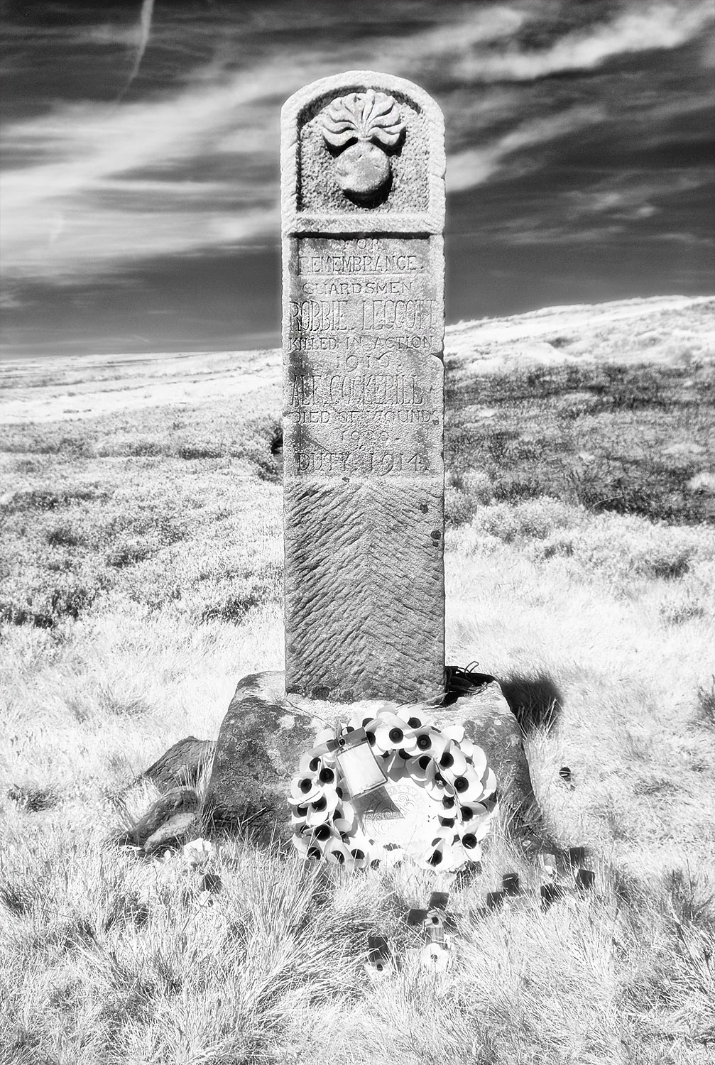
Half way along the valley is a lonely Memorial which commemorates two employees of the Gisborough Estate who were killed during the First World War. Robbie Leggott and Alf Cockerill were Grenadier Guardsmen, Robbie was killed in 1916 at the battle of the Somme aged 19 and Alf was wounded at the Battle of Ypres and later died of his wounds.
At the head of the valley, the Whiteley Beck is joined by the wonderfully named Tidkinhowe Slack. Here you will find a prehistoric monument known as a cross ridge boundary or cross ridge dyke. This monument is called The Bride Stones. The monument is not named on the map but the name is an ancient one. The earliest reference I can find to the name comes from Edward Challoner’s 1716 perambulation of the boundaries of Guisborough.
Guisbrough Boundaries ridden upon the second day of May 1716 Edward Chaloner Esq Lord of the Manor present nigh 200 persons foot and Horse:
Hollbeck on the river that comes by Slapewath to the boundary betwixt the Lordship of Guisbrough and Skelton to Aysdale Gill head So South West by a little Gill or How called Tidkin How directly to a Hill called Hobcrofs So directly to a Hill called Hob on the Hill which is the nighest of the two Hills to the Bride Stones and from thence directly southward to a Stone called Craw Stone and so directly to Ravendale-head to a boundary stone there and from thence to a well called Leaden Well to a Hill called Colemanargus or Todhow and there Guisbrough and Skelton boundaries end.

Dr. Frank Elgee described the Bride Stones in his wonderful book, Early Man in North East Yorkshire published in 1930. Dr Elgee was a remarkable man, he was born into a cultured but poor Middlesbrough family, he suffered a debilitating illness in his early teens that left him in poor physical health for the rest of his life. He was largely self taught and left school at the age of fifteen.
When Elgee was 24 he was appointed Assistant Curator at the Dorman Museum in Middlesbrough. This then enabled him to carry on his researches and writings about all aspects of the North York moors. Extracts from his letters were published in 1991, in a book fittingly entitled A Man of the Moors. This is Elgee’s description of the Bride Stones.
At the head of the North Ings valley we have one of the most remarkable defence works on the moors, one, moreover, which no one seems to have previously noticed. It begins at an altitude of 925 feet on the edge of a steep bluff above Whitley beck, the small stream that flows down the North Ings valley, and it runs almost due north for a third of a mile, to an altitude of 1,000 feet, where its termination is lost in boggy ground at the very head of the Boosbeck valley on the northern side of the watershed. For the greater part of its length it consists of a broad low rampart of earth and stones, with the remains of a fosse on the west side. On the top of this rampart but towards its eastern edge, there runs a line of at least 35 upright stones, 3-5 feet high, of varied shaped and sizes, unhewn, intensely weatherworn, and in places fixed side by side.This work is one of the most impressive relics of antiquity in North-East Yorkshire. Had it not been for the fact that the ancient road to Guisborough has ruthlessly cut through it in many places and that keepers have wantonly used its substantial stones for building the foundations of grouse shooting-butts, it would have been still more impressive.

Stanhope White was another remarkable man of the moors. White was born in Middlesbrough, attended Cambridge University and had worked with The Leakeys at the famous Olduvai Gorge where he made the first maps of the archaeological sites, one of which is named after him. He then spent 20 years working in Nigeria. On returning home he lectured on the geology and archaeology of the moors for the Worker’s Educational Association. below is White’s brief description of the Bride Stones taken from his 1979 book, The North York Moors, An Introduction by Stanhope White.
We now see the first signs of territorial boundaries-which may have arisen from land hunger-in the shape of long earthen banks with upright stones in them at intervals. Such banks would have been useless as defence works, so were in all probability boundary marks between different families, clans or tribes. Examples can be seen near Hob-on-the-Hill close to the track from Guisborough to Commondale. In the earliest perambulation of the boundaries of the Guisborough estates, this line of stones is referred to as ‘The Bridestones’, a name which has been long lost.

Teesside-based Archaeologist, Blaise Vyner has studied the cross ridge boundaries of the North York Moors and has excavated the Bride Stones. The result of his investigations led him to the following construction sequence
Excavation has confirmed and amplified the postulated construction sequence. The first stage of boundary appears to have comprised an alignment of boulders, perhaps quite closely set in groups or even contiuously, with an associated low mound of upcast. After a distinct interval (long enough for the establishment of a humic layer) the character of the boundary was changed with the excavation of a ditch and the construction of a bank which encapsulated the boulder alignment. It seems possible that the bank was topped by a stone construction which may have served to fill the gaps between the protruding boulders, creating a post and panel effect.

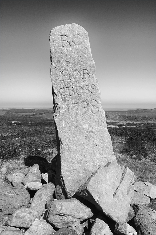
The course of the Bride Stones runs close to two large Bronze Age barrows which are prominently sited on the moorland ridge top. Both of the barrows are skirted by the remains of a megalithic kerb, the larger of the pair is topped with a boundary stone and known as Hob on the Hill. This barrow was excavated by JC Atkinson in 1863 and five burial deposits were discovered.
North York Moors barrows tend to be located on prominent sites and are often inter visible with other barrow groups and prehistoric monuments, this is definitely the case here. The view shed from the barrows takes in the coast from south of Boulby to the mouth of the River Tees and many barrow groups would have been intervisible from the site including the Black Howes, the Warsett Hill Barrow Group and many others across the moors in all directions.
Local Archaeologist Don Spratt examined the prehistoric boundaries of the North York Moors and published a paper on the subject in 1981 (see resources). Spratt proposed a model where barrows mark the watershed boundaries of Bronze Age ‘estates’ . I think Spratt’s model would hold up well at this site.

If you follow the track onto Stanghow Moor you will eventually come to Hob cross. Hobs are prominent characters in local folklore. They are North Yorkshire’s version of ‘the little people,’ small folk who live underground and are often mischievous but rarely malevolent. It is thought that the Hob folklore was introduced to the area by the Danish Viking settlers as a way of explaining the hundreds of Bronze Age moorland monuments. There are several local folktales of Hobs helping out hardworking people in times of troubles, in exchange for food and milk. I find it curious that the name Hob appears on a moorland cross, a christian symbol with a distinctly pagan name. Then again it could be argued that many of the moorland crosses are merely way markers and the word cross just denotes a cross road or path.
Gin Hob mun hae nowght but a hardin’ hamp He’ll come nae mair nowther to berry nor stamp
Resources
Guisbrough History Notes
http://guisboroughhistorynotes.blogspot.co.uk
Early Man in N.E. Yorkshire. Frank Elgee. Bellows. 1930
The North York Moors. An introduction. Stanhope White. Dalesman Publications 1979
Standing Stones & Earthworks on the North Yorkshire Moors. Stanhope White. Fretwell & Cox. 1987
The Brides of Place: cross-ridge boundaries reviewed by Blaise Vyner. Moorland Monuments. CBA Research Report 101 1995
Excavations on Kildale Moor North riding of Yorkshire, 1953. Paul Ashbee. The Yorkshire Archaeological Journal 39. 1953
Bronze Age Burial Mounds in Cleveland. G.M. Crawford. Cleveland County Archaeology Section. 1980
Prehistoric Boundaries on the North Yorshire Moors. Don Spratt. Prehistoric Communities in Northern England. Essays in Economic & Social Reconstruction. University of Sheffield. 1981
Trods of the North York Moors. A Gazetteer of Flagged Paths. Christopher Evans. Scarborough Archaeological & Historical Society. Research report 13. 2008

One thought on “Stones, Shakespeare and Men of the Moors”